Cornillon geodata
Cornillon (Occitanie) is a populated place; located in France in Europe/Paris (GMT+2) time zone. With population of 753 people, there are 11137 cities with bigger population in this country. Compared to other cities in France, 85.3% of cities are located further ↑North; 72% of cities are located further ←West and 57.1% of cities have lower elevation than Cornillon. Note1
Administrative division(s):
- Level 1: Occitanie
- Level 2: Gard
- Level 3: Arrondissement de Nîmes
- Level 4: Cornillon


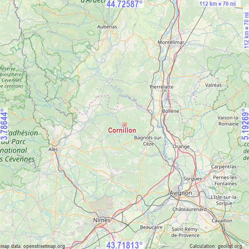
Cornillon GPS coordinates[2]
44° 13' 26.976" North, 4° 29' 22.452" East
| Map corner | latitude | longitude |
|---|---|---|
| Upper-left | 44.72587°, | 3.78644° |
| Center: | 44.22416°, | 4.48957° |
| Lower-right: | 43.71813°, | 5.19269° |
| Map W x H: | 112.1×112 km | = 69.7×69.6mi |
| max Lat: | 51.07786° ⇑85.3% North |
| Cornillon: | 44.22416° |
| min Lat: | ⇓14.7% South 41.3874° |
| min Long | Cornillon | max Long |
| -5.08615° | 4.48957° | 9.52242° |
| W 72%⇐ | ⇒28% E |
Elevation
Elevation of Cornillon is 158 m = 518 ft, and this is 35.7 m = 117 ft below average elevation for this country.
| Max E: |
2333 m = 7654 ft | 42.9% |
| Avg. | 193.7 m = 635 ft | |
| Cornillon | 158 m = 518 ft | |
Min E: |
-1 m = -3 ft | 57.1% |
See also: France elevation on elevation.city.
Geographical zone
Cornillon is located in North temperate zone (between Tropic of Cancer and the Arctic Circle). Distance of this Northern Tropic circle is 2311.3 km =1436.2 mi to South.| Distance of | km | miles | from Cornillon |
|---|---|---|---|
| North Pole | 5089.8 | 3162.7 | to North |
| Arctic Circle | 2483.9 | 1543.4 | to North |
| Tropic Cancer | 2311.3 | 1436.2 | to South |
| Equator | 4917.3 | 3055.5 | to South |


Nearby cities:
15 places around Cornillon: (largest is in red/bold)
• Bagnols-sur-Cèze
12.5 km =7.8 mi,  124°
124°
• Carsan
8.5 km =5.3 mi,  82°
82°
• Cavillargues
12.4 km =7.7 mi,  168°
168°
• Goudargues
2.2 km =1.4 mi,  237°
237°
• Pont-Saint-Esprit
13 km =8.1 mi,  74°
74°
• Sabran
9.4 km =5.8 mi,  150°
150°
• Saint-Alexandre
10.5 km =6.5 mi,  88°
88°
• Saint-Gervais
8.2 km =5.1 mi, 123°
• Saint-Julien-de-Peyrolas
9.3 km =5.8 mi,  40°
40°
• Saint-Just-d'Ardèche
13.2 km =8.2 mi,  50°
50°
• Saint-Laurent-la-Vernède
13.4 km =8.3 mi,  190°
190°
• Saint-Marcel-de-Careiret
9.3 km =5.8 mi,  180°
180°
• Saint-Nazaire
11.1 km =6.9 mi,  104°
104°
• Saint-Paulet-de-Caisson
9.5 km =5.9 mi,  64°
64°
• Vénéjan
13.5 km =8.4 mi, 102°
Sources, notices
• [Note1] Compared only with cities in France existing in our database
• [Src1] Map data: © OpenStreetMap contributors (CC-BY-SA)
• [Src2] Other city data from geonames.org with taken over terms of usage.
• [Src3] Geographical zone / Annual Mean Temperature by Robert A. Rohde @ Wikipedia
