Largentière geodata
Largentière (Auvergne-Rhône-Alpes) is a seat of a third-order administrative division; located in France in Europe/Paris (GMT+2) time zone. With population of 2,126 people, there are 4527 cities with bigger population in this country. Compared to other cities in France, 83.3% of cities are located further ↑North; 70.5% of cities are located further ←West and 77.5% of cities have lower elevation than Largentière. Note1
Administrative division(s):
- Level 1: Auvergne-Rhône-Alpes
- Level 2: Département de l'Ardèche
- Level 3: Arrondissement de Largentière
- Level 4: Largentière


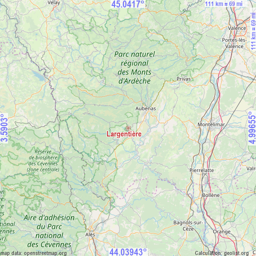
Largentière GPS coordinates[2]
44° 32' 33.792" North, 4° 17' 36.312" East
| Map corner | latitude | longitude |
|---|---|---|
| Upper-left | 45.0417°, | 3.5903° |
| Center: | 44.54272°, | 4.29342° |
| Lower-right: | 44.03943°, | 4.99655° |
| Map W x H: | 111.4×111.4 km | = 69.2×69.2mi |
| max Lat: | 51.07786° ⇑83.3% North |
| Largentière: | 44.54272° |
| min Lat: | ⇓16.7% South 41.3874° |
| min Long | Largentière | max Long |
| -5.08615° | 4.29342° | 9.52242° |
| W 70.5%⇐ | ⇒29.5% E |
Elevation
Elevation of Largentière is 268 m = 879 ft, and this is 74.3 m = 244 ft above average elevation for this country.
| Max E: |
2333 m = 7654 ft | 22.5% |
| Largentière | 268 m 879 ft | |
| Avg. | 193.7 m = 635 ft | |
Min E: |
-1 m = -3 ft | 77.5% |
See also: France elevation on elevation.city.
Geographical zone
Largentière is located in North temperate zone (between Tropic of Cancer and the Arctic Circle). Distance of this Northern Tropic circle is 2346.8 km =1458.2 mi to South.| Distance of | km | miles | from Largentière |
|---|---|---|---|
| North Pole | 5054.4 | 3140.7 | to North |
| Arctic Circle | 2448.5 | 1521.4 | to North |
| Tropic Cancer | 2346.8 | 1458.2 | to South |
| Equator | 4952.7 | 3077.5 | to South |


Nearby cities:
15 places around Largentière: (largest is in red/bold)
• Aubenas
11.5 km =7.1 mi,  41°
41°
• Chassiers
0.9 km =0.6 mi,  16°
16°
• Jaujac
10.9 km =6.8 mi,  344°
344°
• Joyeuse
8.3 km =5.2 mi,  212°
212°
• Lablachère
10.8 km =6.7 mi,  215°
215°
• Lachapelle-sous-Aubenas
6.1 km =3.8 mi,  66°
66°
• Lalevade-d’Ardèche
11.9 km =7.4 mi,  11°
11°
• Laurac-en-Vivarais
3.8 km =2.4 mi,  183°
183°
• Prades
10.7 km =6.6 mi, 8°
• Rosières
7.2 km =4.5 mi,  203°
203°
• Ruoms
10.7 km =6.6 mi,  158°
158°
• Saint-Didier-sous-Aubenas
12 km =7.5 mi,  53°
53°
• Saint-Sernin
8.4 km =5.2 mi, 67°
• Saint-Étienne-de-Fontbellon
9.8 km =6.1 mi, 48°
• Vogüé
9.6 km =6 mi,  84°
84°
Sources, notices
• [Note1] Compared only with cities in France existing in our database
• [Src1] Map data: © OpenStreetMap contributors (CC-BY-SA)
• [Src2] Other city data from geonames.org with taken over terms of usage.
• [Src3] Geographical zone / Annual Mean Temperature by Robert A. Rohde @ Wikipedia
