Rosières geodata
Rosières (Occitanie) is a populated place; located in France in Europe/Paris (GMT+2) time zone. With population of 677 people, there are 12108 cities with bigger population in this country. Compared to other cities in France, 86.7% of cities are located further ↑North; 54.7% of cities are located further →East and 76.2% of cities have lower elevation than Rosières. Note1


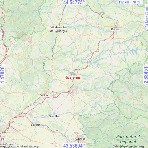
Rosières GPS coordinates[2]
44° 2' 40.2" North, 2° 10' 52.968" East
| Map corner | latitude | longitude |
|---|---|---|
| Upper-left | 44.54775°, | 1.47826° |
| Center: | 44.0445°, | 2.18138° |
| Lower-right: | 43.53694°, | 2.88451° |
| Map W x H: | 112.4×112.4 km | = 69.8×69.8mi |
| max Lat: | 51.07786° ⇑86.7% North |
| Rosières: | 44.0445° |
| min Lat: | ⇓13.3% South 41.3874° |
| min Long | Rosières | max Long |
| -5.08615° | 2.18138° | 9.52242° |
| W 45.3%⇐ | ⇒54.7% E |
Elevation
Elevation of Rosières is 258 m = 846 ft, and this is 64.3 m = 211 ft above average elevation for this country.
| Max E: |
2333 m = 7654 ft | 23.8% |
| Rosières | 258 m 846 ft | |
| Avg. | 193.7 m = 635 ft | |
Min E: |
-1 m = -3 ft | 76.2% |
See also: France elevation on elevation.city.
Geographical zone
Rosières is located in North temperate zone (between Tropic of Cancer and the Arctic Circle). Distance of this Northern Tropic circle is 2291.4 km =1423.8 mi to South.| Distance of | km | miles | from Rosières |
|---|---|---|---|
| North Pole | 5109.8 | 3175.1 | to North |
| Arctic Circle | 2503.9 | 1555.9 | to North |
| Tropic Cancer | 2291.4 | 1423.8 | to South |
| Equator | 4897.3 | 3043 | to South |


Nearby cities:
15 places around Rosières: (largest is in red/bold)
• Albi
13 km =8.1 mi,  191°
191°
• Arthès
10 km =6.2 mi,  166°
166°
• Blaye-les-Mines
4.3 km =2.7 mi,  248°
248°
• Cagnac-les-Mines
7.4 km =4.6 mi,  205°
205°
• Carmaux
2 km =1.2 mi,  291°
291°
• Cunac
13.1 km =8.1 mi, 166°
• Le Garric
4.1 km =2.5 mi,  199°
199°
• Mirandol-Bourgnounac
11 km =6.8 mi,  354°
354°
• Monestiés
7 km =4.3 mi, 290°
• Pampelonne
10.2 km =6.3 mi,  30°
30°
• Saint-Benoît-de-Carmaux
4.2 km =2.6 mi,  278°
278°
• Saint-Juéry
10.9 km =6.8 mi,  164°
164°
• Sainte-Gemme
5.2 km =3.2 mi,  17°
17°
• Tanus
12.6 km =7.8 mi,  59°
59°
• Valderiès
5.5 km =3.4 mi,  131°
131°
Sources, notices
• [Note1] Compared only with cities in France existing in our database
• [Src1] Map data: © OpenStreetMap contributors (CC-BY-SA)
• [Src2] Other city data from geonames.org with taken over terms of usage.
• [Src3] Geographical zone / Annual Mean Temperature by Robert A. Rohde @ Wikipedia
