Roquelaure geodata
Roquelaure (Occitanie) is a populated place; located in France in Europe/Paris (GMT+2) time zone. With population of 513 people, there are 14965 cities with bigger population in this country. Compared to other cities in France, 90.1% of cities are located further ↑North; 72.6% of cities are located further →East and 64.9% of cities have lower elevation than Roquelaure. Note1


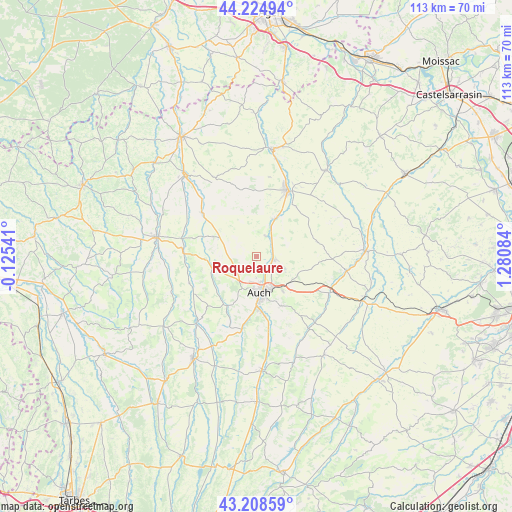
Roquelaure GPS coordinates[2]
43° 43' 8.112" North, 0° 34' 39.756" East
| Map corner | latitude | longitude |
|---|---|---|
| Upper-left | 44.22494°, | -0.12541° |
| Center: | 43.71892°, | 0.57771° |
| Lower-right: | 43.20859°, | 1.28084° |
| Map W x H: | 113×113 km | = 70.2×70.2mi |
| max Lat: | 51.07786° ⇑90.1% North |
| Roquelaure: | 43.71892° |
| min Lat: | ⇓9.9% South 41.3874° |
| min Long | Roquelaure | max Long |
| -5.08615° | 0.57771° | 9.52242° |
| W 27.4%⇐ | ⇒72.6% E |
Elevation
Elevation of Roquelaure is 193 m = 633 ft, and this is 0.69999999999999 m = 2 ft below average elevation for this country.
| Max E: |
2333 m = 7654 ft | 35.1% |
| Avg. | 193.7 m = 635 ft | |
| Roquelaure | 193 m = 633 ft | |
Min E: |
-1 m = -3 ft | 64.9% |
See also: France elevation on elevation.city.
Geographical zone
Roquelaure is located in North temperate zone (between Tropic of Cancer and the Arctic Circle). Distance of this Northern Tropic circle is 2255.2 km =1401.3 mi to South.| Distance of | km | miles | from Roquelaure |
|---|---|---|---|
| North Pole | 5146 | 3197.6 | to North |
| Arctic Circle | 2540.1 | 1578.3 | to North |
| Tropic Cancer | 2255.2 | 1401.3 | to South |
| Equator | 4861.1 | 3020.5 | to South |


Nearby cities:
15 places around Roquelaure: (largest is in red/bold)
• Aubiet
18.5 km =11.5 mi,  115°
115°
• Auch
8.2 km =5.1 mi,  174°
174°
• Auterive
15.5 km =9.6 mi, 169°
• Barran
15.6 km =9.7 mi,  223°
223°
• Castéra-Verduzan
15.2 km =9.4 mi,  309°
309°
• Duran
5.7 km =3.5 mi,  190°
190°
• Fleurance
15.9 km =9.9 mi,  25°
25°
• Jegun
10.4 km =6.5 mi,  300°
300°
• Montestruc-sur-Gers
9.3 km =5.8 mi, 26°
• Ordan-Larroque
10.2 km =6.3 mi,  249°
249°
• Pauilhac
17.7 km =11 mi,  9°
9°
• Pavie
12.2 km =7.6 mi, 174°
• Pessan
12.2 km =7.6 mi,  152°
152°
• Preignan
4 km =2.5 mi,  101°
101°
• Saint-Puy
19.8 km =12.3 mi,  332°
332°
Sources, notices
• [Note1] Compared only with cities in France existing in our database
• [Src1] Map data: © OpenStreetMap contributors (CC-BY-SA)
• [Src2] Other city data from geonames.org with taken over terms of usage.
• [Src3] Geographical zone / Annual Mean Temperature by Robert A. Rohde @ Wikipedia
