Saint-Puy geodata
Saint-Puy (Occitanie) is a populated place; located in France in Europe/Paris (GMT+2) time zone. With population of 630 people, there are 12819 cities with bigger population in this country. Compared to other cities in France, 88.3% of cities are located further ↑North; 73.8% of cities are located further →East and 64.2% of cities have lower elevation than Saint-Puy. Note1
Administrative division(s):
- Level 1: Occitanie
- Level 2: Gers
- Level 3: Arrondissement de Condom
- Level 4: Saint-Puy


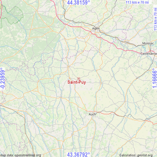
Saint-Puy GPS coordinates[2]
43° 52' 36.876" North, 0° 27' 48.744" East
| Map corner | latitude | longitude |
|---|---|---|
| Upper-left | 44.38159°, | -0.23959° |
| Center: | 43.87691°, | 0.46354° |
| Lower-right: | 43.36792°, | 1.16666° |
| Map W x H: | 112.7×112.7 km | = 70×70mi |
| max Lat: | 51.07786° ⇑88.3% North |
| Saint-Puy: | 43.87691° |
| min Lat: | ⇓11.7% South 41.3874° |
| min Long | Saint-Puy | max Long |
| -5.08615° | 0.46354° | 9.52242° |
| W 26.2%⇐ | ⇒73.8% E |
Elevation
Elevation of Saint-Puy is 190 m = 623 ft, and this is 3.7 m = 12 ft below average elevation for this country.
| Max E: |
2333 m = 7654 ft | 35.8% |
| Avg. | 193.7 m = 635 ft | |
| Saint-Puy | 190 m = 623 ft | |
Min E: |
-1 m = -3 ft | 64.2% |
See also: France elevation on elevation.city.
Geographical zone
Saint-Puy is located in North temperate zone (between Tropic of Cancer and the Arctic Circle). Distance of this Northern Tropic circle is 2272.7 km =1412.2 mi to South.| Distance of | km | miles | from Saint-Puy |
|---|---|---|---|
| North Pole | 5128.4 | 3186.6 | to North |
| Arctic Circle | 2522.5 | 1567.4 | to North |
| Tropic Cancer | 2272.7 | 1412.2 | to South |
| Equator | 4878.7 | 3031.5 | to South |


Nearby cities:
15 places around Saint-Puy: (largest is in red/bold)
• Castéra-Verduzan
8.4 km =5.2 mi,  198°
198°
• Caussens
8 km =5 mi,  336°
336°
• Condom
11.6 km =7.2 mi,  320°
320°
• Fleurance
16.3 km =10.1 mi,  101°
101°
• Gondrin
18.1 km =11.2 mi,  272°
272°
• Jegun
12.3 km =7.6 mi,  178°
178°
• La Romieu
12 km =7.5 mi,  13°
13°
• Lannepax
20.7 km =12.9 mi,  245°
245°
• Lectoure
14.2 km =8.8 mi,  63°
63°
• Moncrabeau
19 km =11.8 mi, 337°
• Montestruc-sur-Gers
16.2 km =10.1 mi,  124°
124°
• Pauilhac
12 km =7.5 mi,  90°
90°
• Roquelaure
19.8 km =12.3 mi,  152°
152°
• Valence-sur-Baïse
6.6 km =4.1 mi,  275°
275°
• Vic-Fezensac
16.8 km =10.4 mi,  225°
225°
Sources, notices
• [Note1] Compared only with cities in France existing in our database
• [Src1] Map data: © OpenStreetMap contributors (CC-BY-SA)
• [Src2] Other city data from geonames.org with taken over terms of usage.
• [Src3] Geographical zone / Annual Mean Temperature by Robert A. Rohde @ Wikipedia
