Fleurance geodata
Fleurance (Occitanie) is a populated place; located in France in Europe/Paris (GMT+2) time zone. With population of 6,564 people, there are 1506 cities with bigger population in this country. Compared to other cities in France, 88.6% of cities are located further ↑North; 71.8% of cities are located further →East and 59.4% of cities have higher elevation than Fleurance. Note1
Administrative division(s):
- Level 1: Occitanie
- Level 2: Gers
- Level 3: Arrondissement de Condom
- Level 4: Fleurance


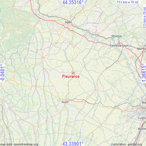
Fleurance GPS coordinates[2]
43° 50' 53.664" North, 0° 39' 46.872" East
| Map corner | latitude | longitude |
|---|---|---|
| Upper-left | 44.35316°, | -0.0401° |
| Center: | 43.84824°, | 0.66302° |
| Lower-right: | 43.33901°, | 1.36615° |
| Map W x H: | 112.8×112.8 km | = 70.1×70.1mi |
| max Lat: | 51.07786° ⇑88.6% North |
| Fleurance: | 43.84824° |
| min Lat: | ⇓11.4% South 41.3874° |
| min Long | Fleurance | max Long |
| -5.08615° | 0.66302° | 9.52242° |
| W 28.2%⇐ | ⇒71.8% E |
Elevation
Elevation of Fleurance is 104 m = 341 ft, and this is 89.7 m = 294 ft below average elevation for this country.
| Max E: |
2333 m = 7654 ft | 59.4% |
| Avg. | 193.7 m = 635 ft | |
| Fleurance | 104 m = 341 ft | |
Min E: |
-1 m = -3 ft | 40.6% |
See also: France elevation on elevation.city.
Geographical zone
Fleurance is located in North temperate zone (between Tropic of Cancer and the Arctic Circle). Distance of this Northern Tropic circle is 2269.5 km =1410.2 mi to South.| Distance of | km | miles | from Fleurance |
|---|---|---|---|
| North Pole | 5131.6 | 3188.6 | to North |
| Arctic Circle | 2525.7 | 1569.4 | to North |
| Tropic Cancer | 2269.5 | 1410.2 | to South |
| Equator | 4875.5 | 3029.5 | to South |


Nearby cities:
15 places around Fleurance: (largest is in red/bold)
• Castéra-Verduzan
19.2 km =11.9 mi,  255°
255°
• Caussens
21.9 km =13.6 mi,  298°
298°
• Duran
21.5 km =13.4 mi,  201°
201°
• Jegun
18.2 km =11.3 mi,  240°
240°
• La Romieu
19.8 km =12.3 mi,  318°
318°
• Lectoure
10.2 km =6.3 mi,  340°
340°
• Marignac
20 km =12.4 mi,  91°
91°
• Mauvezin
21.7 km =13.5 mi,  127°
127°
• Miradoux
18.3 km =11.4 mi,  24°
24°
• Montestruc-sur-Gers
6.6 km =4.1 mi, 204°
• Pauilhac
5.1 km =3.2 mi,  307°
307°
• Preignan
15.5 km =9.6 mi,  191°
191°
• Roquelaure
15.9 km =9.9 mi,  205°
205°
• Saint-Clar
9.8 km =6.1 mi,  61°
61°
• Saint-Puy
16.3 km =10.1 mi,  281°
281°
Sources, notices
• [Note1] Compared only with cities in France existing in our database
• [Src1] Map data: © OpenStreetMap contributors (CC-BY-SA)
• [Src2] Other city data from geonames.org with taken over terms of usage.
• [Src3] Geographical zone / Annual Mean Temperature by Robert A. Rohde @ Wikipedia
