Rom geodata
Rom (Nouvelle-Aquitaine) is a populated place; located in France in Europe/Paris (GMT+2) time zone. With population of 818 people, there are 10409 cities with bigger population in this country. Compared to other cities in France, 62.4% of cities are located further ↑North; 77.1% of cities are located further →East and 53.8% of cities have higher elevation than Rom. Note1
Administrative division(s):
- Level 1: Nouvelle-Aquitaine
- Level 2: Département des Deux-Sèvres
- Level 3: Arrondissement de Niort
- Level 4: Rom


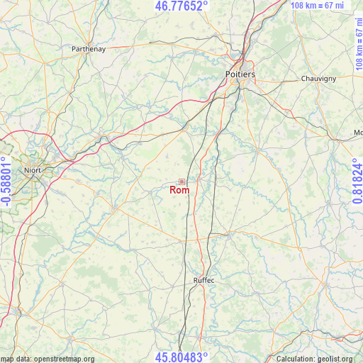
Rom GPS coordinates[2]
46° 17' 34.188" North, 0° 6' 54.432" East
| Map corner | latitude | longitude |
|---|---|---|
| Upper-left | 46.77652°, | -0.58801° |
| Center: | 46.29283°, | 0.11512° |
| Lower-right: | 45.80483°, | 0.81824° |
| Map W x H: | 108×108 km | = 67.1×67.1mi |
| max Lat: | 51.07786° ⇑62.4% North |
| Rom: | 46.29283° |
| min Lat: | ⇓37.6% South 41.3874° |
| min Long | Rom | max Long |
| -5.08615° | 0.11512° | 9.52242° |
| W 22.9%⇐ | ⇒77.1% E |
Elevation
Elevation of Rom is 120 m = 394 ft, and this is 73.7 m = 242 ft below average elevation for this country.
| Max E: |
2333 m = 7654 ft | 53.8% |
| Avg. | 193.7 m = 635 ft | |
| Rom | 120 m = 394 ft | |
Min E: |
-1 m = -3 ft | 46.2% |
See also: France elevation on elevation.city.
Geographical zone
Rom is located in North temperate zone (between Tropic of Cancer and the Arctic Circle). Distance of this North polar circle is 2253.9 km =1400.5 mi to North.| Distance of | km | miles | from Rom |
|---|---|---|---|
| North Pole | 4859.8 | 3019.7 | to North |
| Arctic Circle | 2253.9 | 1400.5 | to North |
| Tropic Cancer | 2541.4 | 1579.2 | to South |
| Equator | 5147.3 | 3198.4 | to South |


Nearby cities:
15 places around Rom: (largest is in red/bold)
• Blanzay
14.8 km =9.2 mi,  133°
133°
• Brux
8.7 km =5.4 mi,  136°
136°
• Ceaux-en-Couhé
9.5 km =5.9 mi,  73°
73°
• Chaunay
10.2 km =6.3 mi,  158°
158°
• Chenay
12 km =7.5 mi,  287°
287°
• Chey
12.8 km =8 mi,  275°
275°
• Clussais
12 km =7.5 mi,  205°
205°
• Couhé
5.2 km =3.2 mi,  81°
81°
• Lezay
10 km =6.2 mi,  252°
252°
• Payré
9.1 km =5.7 mi,  54°
54°
• Romagne
14.6 km =9.1 mi,  99°
99°
• Rouillé
15.3 km =9.5 mi,  337°
337°
• Saint-Sauvant
8.8 km =5.5 mi,  329°
329°
• Saint-Vincent-la-Châtre
14.2 km =8.8 mi,  235°
235°
• Vaux
8.2 km =5.1 mi,  85°
85°
Sources, notices
• [Note1] Compared only with cities in France existing in our database
• [Src1] Map data: © OpenStreetMap contributors (CC-BY-SA)
• [Src2] Other city data from geonames.org with taken over terms of usage.
• [Src3] Geographical zone / Annual Mean Temperature by Robert A. Rohde @ Wikipedia
