Chaunay geodata
Chaunay (Nouvelle-Aquitaine) is a populated place; located in France in Europe/Paris (GMT+2) time zone. With population of 1,257 people, there are 7244 cities with bigger population in this country. Compared to other cities in France, 63.4% of cities are located further ↑North; 76.6% of cities are located further →East and 50.3% of cities have lower elevation than Chaunay. Note1
Administrative division(s):
- Level 1: Nouvelle-Aquitaine
- Level 2: Vienne
- Level 3: Arrondissement de Montmorillon
- Level 4: Chaunay


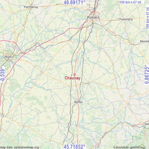
Chaunay GPS coordinates[2]
46° 12' 26.172" North, 0° 9' 50.832" East
| Map corner | latitude | longitude |
|---|---|---|
| Upper-left | 46.69171°, | -0.539° |
| Center: | 46.20727°, | 0.16412° |
| Lower-right: | 45.71852°, | 0.86725° |
| Map W x H: | 108.2×108.2 km | = 67.2×67.2mi |
| max Lat: | 51.07786° ⇑63.4% North |
| Chaunay: | 46.20727° |
| min Lat: | ⇓36.6% South 41.3874° |
| min Long | Chaunay | max Long |
| -5.08615° | 0.16412° | 9.52242° |
| W 23.4%⇐ | ⇒76.6% E |
Elevation
Elevation of Chaunay is 133 m = 436 ft, and this is 60.7 m = 199 ft below average elevation for this country.
| Max E: |
2333 m = 7654 ft | 49.7% |
| Avg. | 193.7 m = 635 ft | |
| Chaunay | 133 m = 436 ft | |
Min E: |
-1 m = -3 ft | 50.3% |
See also: France elevation on elevation.city.
Geographical zone
Chaunay is located in North temperate zone (between Tropic of Cancer and the Arctic Circle). Distance of this North polar circle is 2263.4 km =1406.4 mi to North.| Distance of | km | miles | from Chaunay |
|---|---|---|---|
| North Pole | 4869.3 | 3025.6 | to North |
| Arctic Circle | 2263.4 | 1406.4 | to North |
| Tropic Cancer | 2531.8 | 1573.2 | to South |
| Equator | 5137.8 | 3192.5 | to South |


Nearby cities:
15 places around Chaunay: (largest is in red/bold)
• Blanzay
7.1 km =4.4 mi,  95°
95°
• Brux
3.9 km =2.4 mi,  34°
34°
• Ceaux-en-Couhé
13.3 km =8.3 mi,  23°
23°
• Civray
12 km =7.5 mi,  123°
123°
• Clussais
9 km =5.6 mi,  261°
261°
• Couhé
10.4 km =6.5 mi,  7°
7°
• Lezay
14.8 km =9.2 mi,  295°
295°
• Limalonges
8.6 km =5.3 mi,  177°
177°
• Melleran
15.1 km =9.4 mi,  236°
236°
• Payré
15.3 km =9.5 mi, 13°
• Rom
10.2 km =6.3 mi,  338°
338°
• Romagne
12.7 km =7.9 mi,  56°
56°
• Sauzé-Vaussais
9.3 km =5.8 mi,  208°
208°
• Savigné
13.2 km =8.2 mi,  113°
113°
• Vaux
11 km =6.8 mi, 23°
Sources, notices
• [Note1] Compared only with cities in France existing in our database
• [Src1] Map data: © OpenStreetMap contributors (CC-BY-SA)
• [Src2] Other city data from geonames.org with taken over terms of usage.
• [Src3] Geographical zone / Annual Mean Temperature by Robert A. Rohde @ Wikipedia
