Payré geodata
Payré (Nouvelle-Aquitaine) is a populated place; located in France in Europe/Paris (GMT+2) time zone. With population of 975 people, there are 9023 cities with bigger population in this country. Compared to other cities in France, 61.8% of cities are located further ↑North; 76.2% of cities are located further →East and 57.9% of cities have higher elevation than Payré. Note1
Administrative division(s):
- Level 1: Nouvelle-Aquitaine
- Level 2: Vienne
- Level 3: Arrondissement de Montmorillon
- Level 4: Valence-en-Poitou


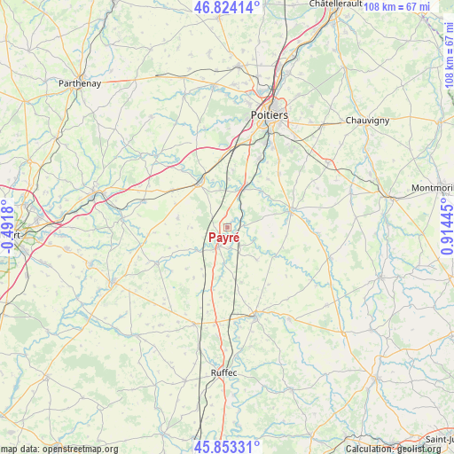
Payré GPS coordinates[2]
46° 20' 27.168" North, 0° 12' 40.788" East
| Map corner | latitude | longitude |
|---|---|---|
| Upper-left | 46.82414°, | -0.4918° |
| Center: | 46.34088°, | 0.21133° |
| Lower-right: | 45.85331°, | 0.91445° |
| Map W x H: | 107.9×107.9 km | = 67×67mi |
| max Lat: | 51.07786° ⇑61.8% North |
| Payré: | 46.34088° |
| min Lat: | ⇓38.2% South 41.3874° |
| min Long | Payré | max Long |
| -5.08615° | 0.21133° | 9.52242° |
| W 23.8%⇐ | ⇒76.2% E |
Elevation
Elevation of Payré is 108 m = 354 ft, and this is 85.7 m = 281 ft below average elevation for this country.
| Max E: |
2333 m = 7654 ft | 57.9% |
| Avg. | 193.7 m = 635 ft | |
| Payré | 108 m = 354 ft | |
Min E: |
-1 m = -3 ft | 42.1% |
See also: France elevation on elevation.city.
Geographical zone
Payré is located in North temperate zone (between Tropic of Cancer and the Arctic Circle). Distance of this North polar circle is 2248.6 km =1397.2 mi to North.| Distance of | km | miles | from Payré |
|---|---|---|---|
| North Pole | 4854.4 | 3016.4 | to North |
| Arctic Circle | 2248.6 | 1397.2 | to North |
| Tropic Cancer | 2546.7 | 1582.4 | to South |
| Equator | 5152.6 | 3201.7 | to South |


Nearby cities:
15 places around Payré: (largest is in red/bold)
• Aslonnes
11.4 km =7.1 mi,  54°
54°
• Brux
11.8 km =7.3 mi,  186°
186°
• Ceaux-en-Couhé
3.2 km =2 mi,  147°
147°
• Celle-Lévescault
9.4 km =5.8 mi,  348°
348°
• Champagné-Saint-Hilaire
9 km =5.6 mi,  105°
105°
• Château-Larcher
11.6 km =7.2 mi,  42°
42°
• Couhé
5.1 km =3.2 mi,  206°
206°
• Lusignan
12.5 km =7.8 mi,  326°
326°
• Marnay
11.8 km =7.3 mi,  58°
58°
• Rom
9.1 km =5.7 mi,  234°
234°
• Romagne
10.5 km =6.5 mi,  138°
138°
• Saint-Sauvant
12.1 km =7.5 mi,  280°
280°
• Sommières-du-Clain
13.2 km =8.2 mi,  121°
121°
• Vaux
4.8 km =3 mi,  170°
170°
• Vivonne
10.7 km =6.6 mi,  22°
22°
Sources, notices
• [Note1] Compared only with cities in France existing in our database
• [Src1] Map data: © OpenStreetMap contributors (CC-BY-SA)
• [Src2] Other city data from geonames.org with taken over terms of usage.
• [Src3] Geographical zone / Annual Mean Temperature by Robert A. Rohde @ Wikipedia
