Lezay geodata
Lezay (Nouvelle-Aquitaine) is a populated place; located in France in Europe/Paris (GMT+2) time zone. With population of 2,176 people, there are 4411 cities with bigger population in this country. Compared to other cities in France, 62.7% of cities are located further ↑North; 78.2% of cities are located further →East and 50.2% of cities have higher elevation than Lezay. Note1
Administrative division(s):
- Level 1: Nouvelle-Aquitaine
- Level 2: Département des Deux-Sèvres
- Level 3: Arrondissement de Niort
- Level 4: Lezay


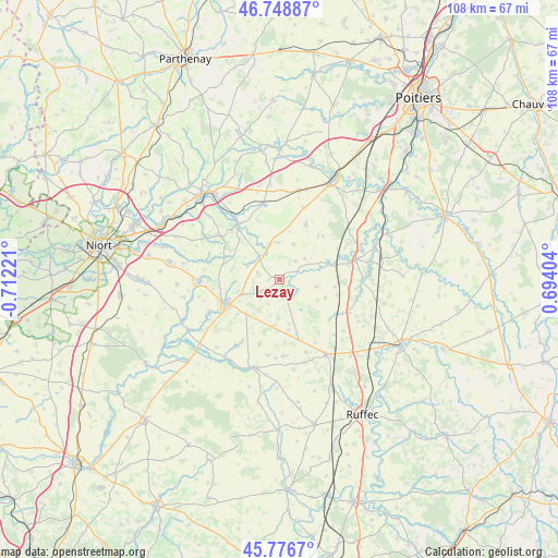
Lezay GPS coordinates[2]
46° 15' 53.784" North, 0° 0' 32.724" West
| Map corner | latitude | longitude |
|---|---|---|
| Upper-left | 46.74887°, | -0.71221° |
| Center: | 46.26494°, | -0.00909° |
| Lower-right: | 45.7767°, | 0.69404° |
| Map W x H: | 108.1×108.1 km | = 67.2×67.2mi |
| max Lat: | 51.07786° ⇑62.7% North |
| Lezay: | 46.26494° |
| min Lat: | ⇓37.3% South 41.3874° |
| min Long | Lezay | max Long |
| -5.08615° | -0.00909° | 9.52242° |
| W 21.8%⇐ | ⇒78.2% E |
Elevation
Elevation of Lezay is 131 m = 430 ft, and this is 62.7 m = 206 ft below average elevation for this country.
| Max E: |
2333 m = 7654 ft | 50.2% |
| Avg. | 193.7 m = 635 ft | |
| Lezay | 131 m = 430 ft | |
Min E: |
-1 m = -3 ft | 49.8% |
See also: France elevation on elevation.city.
Geographical zone
Lezay is located in North temperate zone (between Tropic of Cancer and the Arctic Circle). Distance of this North polar circle is 2257 km =1402.4 mi to North.| Distance of | km | miles | from Lezay |
|---|---|---|---|
| North Pole | 4862.9 | 3021.7 | to North |
| Arctic Circle | 2257 | 1402.4 | to North |
| Tropic Cancer | 2538.3 | 1577.2 | to South |
| Equator | 5144.2 | 3196.5 | to South |


Nearby cities:
15 places around Lezay: (largest is in red/bold)
• Chaunay
14.8 km =9.2 mi,  115°
115°
• Chenay
7 km =4.3 mi,  344°
344°
• Chey
5.4 km =3.4 mi,  323°
323°
• Clussais
8.8 km =5.5 mi,  150°
150°
• Exoudun
10.4 km =6.5 mi,  327°
327°
• Gournay-Loizé
13.2 km =8.2 mi,  193°
193°
• La Mothe-Saint-Héray
13.3 km =8.3 mi, 323°
• Melle
11.3 km =7 mi,  246°
246°
• Melleran
14.8 km =9.2 mi,  176°
176°
• Pamproux
15 km =9.3 mi,  346°
346°
• Rom
10 km =6.2 mi,  72°
72°
• Saint-Martin-lès-Melle
12.9 km =8 mi, 247°
• Saint-Sauvant
11.8 km =7.3 mi,  25°
25°
• Saint-Vincent-la-Châtre
5.3 km =3.3 mi,  204°
204°
• Vitré
14.6 km =9.1 mi,  277°
277°
Sources, notices
• [Note1] Compared only with cities in France existing in our database
• [Src1] Map data: © OpenStreetMap contributors (CC-BY-SA)
• [Src2] Other city data from geonames.org with taken over terms of usage.
• [Src3] Geographical zone / Annual Mean Temperature by Robert A. Rohde @ Wikipedia
