Roeschwoog geodata
Roeschwoog (Grand Est) is a populated place; located in France in Europe/Paris (GMT+2) time zone. With population of 2,156 people, there are 4461 cities with bigger population in this country. Compared to other cities in France, 76.1% of cities are located further ↓South; 99.4% of cities are located further ←West and 54.1% of cities have higher elevation than Roeschwoog. Note1
Administrative division(s):
- Level 1: Grand Est
- Level 2: Bas-Rhin
- Level 3: Arrondissement de Haguenau-Wissembourg
- Level 4: Rœschwoog


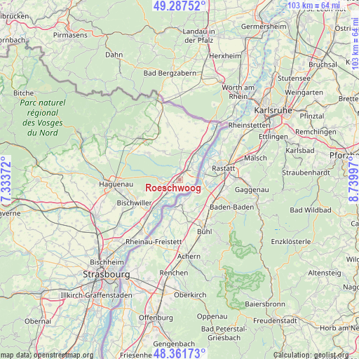
Roeschwoog GPS coordinates[2]
48° 49' 36.336" North, 8° 2' 12.624" East
| Map corner | latitude | longitude |
|---|---|---|
| Upper-left | 49.28752°, | 7.33372° |
| Center: | 48.82676°, | 8.03684° |
| Lower-right: | 48.36173°, | 8.73997° |
| Map W x H: | 102.9×102.9 km | = 63.9×63.9mi |
| max Lat: | 51.07786° ⇑23.9% North |
| Roeschwoog: | 48.82676° |
| min Lat: | ⇓76.1% South 41.3874° |
| min Long | Roeschwoog | max Long |
| -5.08615° | 8.03684° | 9.52242° |
| W 99.4%⇐ | ⇒0.59999999999999% E |
Elevation
Elevation of Roeschwoog is 119 m = 390 ft, and this is 74.7 m = 245 ft below average elevation for this country.
| Max E: |
2333 m = 7654 ft | 54.1% |
| Avg. | 193.7 m = 635 ft | |
| Roeschwoog | 119 m = 390 ft | |
Min E: |
-1 m = -3 ft | 45.9% |
See also: France elevation on elevation.city.
Geographical zone
Roeschwoog is located in North temperate zone (between Tropic of Cancer and the Arctic Circle). Distance of this North polar circle is 1972.1 km =1225.4 mi to North.| Distance of | km | miles | from Roeschwoog |
|---|---|---|---|
| North Pole | 4578 | 2844.6 | to North |
| Arctic Circle | 1972.1 | 1225.4 | to North |
| Tropic Cancer | 2823.1 | 1754.2 | to South |
| Equator | 5429 | 3373.4 | to South |


Nearby cities:
15 places around Roeschwoog: (largest is in red/bold)
• Betschdorf
12.7 km =7.9 mi,  308°
308°
• Bischwiller
14.9 km =9.3 mi,  244°
244°
• Drusenheim
9.4 km =5.8 mi,  220°
220°
• Hatten
9.3 km =5.8 mi,  333°
333°
• Herrlisheim
14.4 km =8.9 mi, 221°
• Kaltenhouse
15.5 km =9.6 mi,  255°
255°
• Kutzenhausen
17.9 km =11.1 mi, 311°
• Oberhoffen-sur-Moder
13.6 km =8.5 mi,  249°
249°
• Roppenheim
2 km =1.2 mi,  35°
35°
• Schirrhein
10 km =6.2 mi, 253°
• Seltz
9.2 km =5.7 mi,  34°
34°
• Sessenheim
5 km =3.1 mi,  227°
227°
• Soufflenheim
5.4 km =3.4 mi,  274°
274°
• Soultz-sous-Forêts
16.7 km =10.4 mi,  317°
317°
• Surbourg
16.7 km =10.4 mi,  303°
303°
Sources, notices
• [Note1] Compared only with cities in France existing in our database
• [Src1] Map data: © OpenStreetMap contributors (CC-BY-SA)
• [Src2] Other city data from geonames.org with taken over terms of usage.
• [Src3] Geographical zone / Annual Mean Temperature by Robert A. Rohde @ Wikipedia
