Kaltenhouse geodata
Kaltenhouse (Grand Est) is a populated place; located in France in Europe/Paris (GMT+2) time zone. With population of 2,000 people, there are 4792 cities with bigger population in this country. Compared to other cities in France, 75.3% of cities are located further ↓South; 99.3% of cities are located further ←West and 53.9% of cities have lower elevation than Kaltenhouse. Note1
Administrative division(s):
- Level 1: Grand Est
- Level 2: Bas-Rhin
- Level 3: Arrondissement de Haguenau-Wissembourg
- Level 4: Kaltenhouse


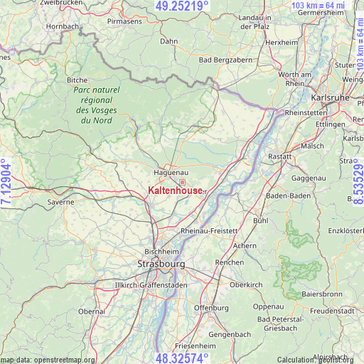
Kaltenhouse GPS coordinates[2]
48° 47' 27.96" North, 7° 49' 55.812" East
| Map corner | latitude | longitude |
|---|---|---|
| Upper-left | 49.25219°, | 7.12904° |
| Center: | 48.7911°, | 7.83217° |
| Lower-right: | 48.32574°, | 8.53529° |
| Map W x H: | 103×103 km | = 64×64mi |
| max Lat: | 51.07786° ⇑24.7% North |
| Kaltenhouse: | 48.7911° |
| min Lat: | ⇓75.3% South 41.3874° |
| min Long | Kaltenhouse | max Long |
| -5.08615° | 7.83217° | 9.52242° |
| W 99.3%⇐ | ⇒0.7% E |
Elevation
Elevation of Kaltenhouse is 146 m = 479 ft, and this is 47.7 m = 156 ft below average elevation for this country.
| Max E: |
2333 m = 7654 ft | 46.1% |
| Avg. | 193.7 m = 635 ft | |
| Kaltenhouse | 146 m = 479 ft | |
Min E: |
-1 m = -3 ft | 53.9% |
See also: France elevation on elevation.city.
Geographical zone
Kaltenhouse is located in North temperate zone (between Tropic of Cancer and the Arctic Circle). Distance of this North polar circle is 1976.1 km =1227.9 mi to North.| Distance of | km | miles | from Kaltenhouse |
|---|---|---|---|
| North Pole | 4582 | 2847.1 | to North |
| Arctic Circle | 1976.1 | 1227.9 | to North |
| Tropic Cancer | 2819.1 | 1751.7 | to South |
| Equator | 5425.1 | 3371 | to South |


Nearby cities:
15 places around Kaltenhouse: (largest is in red/bold)
• Batzendorf
9.3 km =5.8 mi,  264°
264°
• Bischwiller
3 km =1.9 mi,  147°
147°
• Drusenheim
9.4 km =5.8 mi,  109°
109°
• Geudertheim
9.5 km =5.9 mi,  218°
218°
• Gries
4.4 km =2.7 mi,  197°
197°
• Haguenau
4.1 km =2.5 mi,  311°
311°
• Herrlisheim
8.6 km =5.3 mi,  141°
141°
• Kriegsheim
8.4 km =5.2 mi,  244°
244°
• Kurtzenhouse
6 km =3.7 mi, 199°
• Niederschaeffolsheim
7.2 km =4.5 mi,  253°
253°
• Oberhoffen-sur-Moder
2.4 km =1.5 mi, 109°
• Schirrhein
5.5 km =3.4 mi,  77°
77°
• Schweighouse-sur-Moder
8.3 km =5.2 mi,  292°
292°
• Weitbruch
5.6 km =3.5 mi, 223°
• Weyersheim
8.6 km =5.3 mi, 195°
Sources, notices
• [Note1] Compared only with cities in France existing in our database
• [Src1] Map data: © OpenStreetMap contributors (CC-BY-SA)
• [Src2] Other city data from geonames.org with taken over terms of usage.
• [Src3] Geographical zone / Annual Mean Temperature by Robert A. Rohde @ Wikipedia
