Rieutort-de-Randon geodata
Rieutort-de-Randon (Occitanie) is a populated place; located in France in Europe/Paris (GMT+2) time zone. With population of 677 people, there are 12108 cities with bigger population in this country. Compared to other cities in France, 82.6% of cities are located further ↑North; 64.1% of cities are located further ←West and 99.6% of cities have lower elevation than Rieutort-de-Randon. Note1
Administrative division(s):
- Level 1: Occitanie
- Level 2: Département de la Lozère
- Level 3: Arrondissement de Mende
- Level 4: Monts-de-Randon


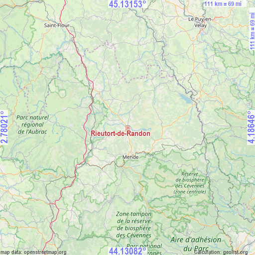
Rieutort-de-Randon GPS coordinates[2]
44° 37' 59.988" North, 3° 28' 59.988" East
| Map corner | latitude | longitude |
|---|---|---|
| Upper-left | 45.13153°, | 2.78021° |
| Center: | 44.63333°, | 3.48333° |
| Lower-right: | 44.13082°, | 4.18646° |
| Map W x H: | 111.3×111.3 km | = 69.2×69.2mi |
| max Lat: | 51.07786° ⇑82.6% North |
| Rieutort-de-Randon: | 44.63333° |
| min Lat: | ⇓17.4% South 41.3874° |
| min Long | Rieutort-de-Ran | max Long |
| -5.08615° | 3.48333° | 9.52242° |
| W 64.1%⇐ | ⇒35.9% E |
Elevation
Elevation of Rieutort-de-Randon is 1177 m = 3862 ft, and this is 983.3 m = 3226 ft above average elevation for this country.
| Max E: |
2333 m = 7654 ft | 0.40000000000001% |
| Rieutort-de-Randon | 1177 m 3862 ft | |
| Avg. | 193.7 m = 635 ft | |
Min E: |
-1 m = -3 ft | 99.6% |
See also: France elevation on elevation.city.
Geographical zone
Rieutort-de-Randon is located in North temperate zone (between Tropic of Cancer and the Arctic Circle). Distance of this Northern Tropic circle is 2356.8 km =1464.4 mi to South.| Distance of | km | miles | from Rieutort-de-Randon |
|---|---|---|---|
| North Pole | 5044.3 | 3134.4 | to North |
| Arctic Circle | 2438.4 | 1515.2 | to North |
| Tropic Cancer | 2356.8 | 1464.4 | to South |
| Equator | 4962.8 | 3083.7 | to South |


Nearby cities:
15 places around Rieutort-de-Randon: (largest is in red/bold)
• Aumont-Aubrac
18.5 km =11.5 mi,  302°
302°
• Badaroux
12.1 km =7.5 mi,  155°
155°
• Balsièges
17.1 km =10.6 mi,  187°
187°
• Barjac
15.6 km =9.7 mi,  201°
201°
• Chanac
21.7 km =13.5 mi,  210°
210°
• Chastel-Nouvel
8.4 km =5.2 mi,  170°
170°
• Chirac
21.1 km =13.1 mi,  234°
234°
• Châteauneuf-de-Randon
15.2 km =9.4 mi,  87°
87°
• Grandrieu
20.6 km =12.8 mi,  35°
35°
• Marvejols
17.6 km =10.9 mi,  239°
239°
• Mende
12.9 km =8 mi, 172°
• Montrodat
15.3 km =9.5 mi, 232°
• Rimeize
19.3 km =12 mi,  319°
319°
• Saint-Alban-sur-Limagnole
18.1 km =11.2 mi,  335°
335°
• Saint-Étienne-du-Valdonnez
20.7 km =12.9 mi, 162°
Sources, notices
• [Note1] Compared only with cities in France existing in our database
• [Src1] Map data: © OpenStreetMap contributors (CC-BY-SA)
• [Src2] Other city data from geonames.org with taken over terms of usage.
• [Src3] Geographical zone / Annual Mean Temperature by Robert A. Rohde @ Wikipedia
