Barjac geodata
Barjac (Occitanie) is a populated place; located in France in Europe/Paris (GMT+2) time zone. With population of 629 people, there are 12831 cities with bigger population in this country. Compared to other cities in France, 83.5% of cities are located further ↑North; 63.3% of cities are located further ←West and 96.3% of cities have lower elevation than Barjac. Note1
Administrative division(s):
- Level 1: Occitanie
- Level 2: Département de la Lozère
- Level 3: Arrondissement de Mende
- Level 4: Barjac


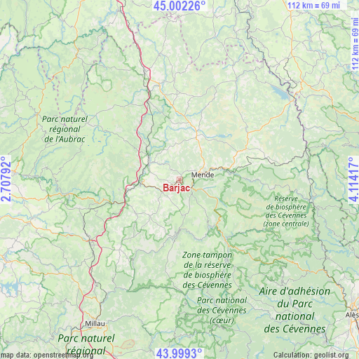
Barjac GPS coordinates[2]
44° 30' 10.584" North, 3° 24' 39.78" East
| Map corner | latitude | longitude |
|---|---|---|
| Upper-left | 45.00226°, | 2.70792° |
| Center: | 44.50294°, | 3.41105° |
| Lower-right: | 43.9993°, | 4.11417° |
| Map W x H: | 111.5×111.5 km | = 69.3×69.3mi |
| max Lat: | 51.07786° ⇑83.5% North |
| Barjac: | 44.50294° |
| min Lat: | ⇓16.5% South 41.3874° |
| min Long | Barjac | max Long |
| -5.08615° | 3.41105° | 9.52242° |
| W 63.3%⇐ | ⇒36.7% E |
Elevation
Elevation of Barjac is 665 m = 2182 ft, and this is 471.3 m = 1546 ft above average elevation for this country.
| Max E: |
2333 m = 7654 ft | 3.7% |
| Barjac | 665 m 2182 ft | |
| Avg. | 193.7 m = 635 ft | |
Min E: |
-1 m = -3 ft | 96.3% |
See also: France elevation on elevation.city.
Geographical zone
Barjac is located in North temperate zone (between Tropic of Cancer and the Arctic Circle). Distance of this Northern Tropic circle is 2342.3 km =1455.4 mi to South.| Distance of | km | miles | from Barjac |
|---|---|---|---|
| North Pole | 5058.8 | 3143.4 | to North |
| Arctic Circle | 2452.9 | 1524.2 | to North |
| Tropic Cancer | 2342.3 | 1455.4 | to South |
| Equator | 4948.3 | 3074.7 | to South |


Nearby cities:
15 places around Barjac: (largest is in red/bold)
• Badaroux
11.3 km =7 mi,  72°
72°
• Balsièges
4.4 km =2.7 mi,  124°
124°
• Banassac
18.3 km =11.4 mi,  246°
246°
• Chanac
6.8 km =4.2 mi,  232°
232°
• Chastel-Nouvel
9.4 km =5.8 mi,  49°
49°
• Chirac
11.7 km =7.3 mi,  280°
280°
• Ispagnac
17.8 km =11.1 mi,  145°
145°
• La Canourgue
17.4 km =10.8 mi,  242°
242°
• Le Monastier-Pin-Moriès
12.9 km =8 mi, 276°
• Marvejols
11 km =6.8 mi,  300°
300°
• Mende
7.5 km =4.7 mi,  76°
76°
• Montrodat
8.4 km =5.2 mi,  309°
309°
• Rieutort-de-Randon
15.6 km =9.7 mi,  21°
21°
• Saint-Étienne-du-Valdonnez
13.2 km =8.2 mi,  113°
113°
• Sainte-Enimie
15.2 km =9.4 mi,  178°
178°
Sources, notices
• [Note1] Compared only with cities in France existing in our database
• [Src1] Map data: © OpenStreetMap contributors (CC-BY-SA)
• [Src2] Other city data from geonames.org with taken over terms of usage.
• [Src3] Geographical zone / Annual Mean Temperature by Robert A. Rohde @ Wikipedia
