Chanac geodata
Chanac (Occitanie) is a populated place; located in France in Europe/Paris (GMT+2) time zone. With population of 1,212 people, there are 7468 cities with bigger population in this country. Compared to other cities in France, 83.8% of cities are located further ↑North; 62.5% of cities are located further ←West and 96.3% of cities have lower elevation than Chanac. Note1
Administrative division(s):
- Level 1: Occitanie
- Level 2: Département de la Lozère
- Level 3: Arrondissement de Mende
- Level 4: Chanac


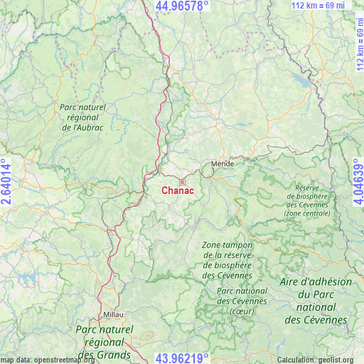
Chanac GPS coordinates[2]
44° 27' 58.104" North, 3° 20' 35.772" East
| Map corner | latitude | longitude |
|---|---|---|
| Upper-left | 44.96578°, | 2.64014° |
| Center: | 44.46614°, | 3.34327° |
| Lower-right: | 43.96219°, | 4.04639° |
| Map W x H: | 111.6×111.6 km | = 69.3×69.3mi |
| max Lat: | 51.07786° ⇑83.8% North |
| Chanac: | 44.46614° |
| min Lat: | ⇓16.2% South 41.3874° |
| min Long | Chanac | max Long |
| -5.08615° | 3.34327° | 9.52242° |
| W 62.5%⇐ | ⇒37.5% E |
Elevation
Elevation of Chanac is 666 m = 2185 ft, and this is 472.3 m = 1550 ft above average elevation for this country.
| Max E: |
2333 m = 7654 ft | 3.7% |
| Chanac | 666 m 2185 ft | |
| Avg. | 193.7 m = 635 ft | |
Min E: |
-1 m = -3 ft | 96.3% |
See also: France elevation on elevation.city.
Geographical zone
Chanac is located in North temperate zone (between Tropic of Cancer and the Arctic Circle). Distance of this Northern Tropic circle is 2338.3 km =1453 mi to South.| Distance of | km | miles | from Chanac |
|---|---|---|---|
| North Pole | 5062.9 | 3145.9 | to North |
| Arctic Circle | 2457 | 1526.7 | to North |
| Tropic Cancer | 2338.3 | 1453 | to South |
| Equator | 4944.2 | 3072.2 | to South |


Nearby cities:
15 places around Chanac: (largest is in red/bold)
• Badaroux
17.9 km =11.1 mi,  64°
64°
• Balsièges
9.2 km =5.7 mi,  80°
80°
• Banassac
11.9 km =7.4 mi,  253°
253°
• Barjac
6.8 km =4.2 mi,  52°
52°
• Chastel-Nouvel
16.2 km =10.1 mi, 50°
• Chirac
8.8 km =5.5 mi,  316°
316°
• Ispagnac
18.8 km =11.7 mi,  124°
124°
• La Canourgue
10.8 km =6.7 mi, 249°
• Le Monastier-Pin-Moriès
9.3 km =5.8 mi,  307°
307°
• Marvejols
10.6 km =6.6 mi,  337°
337°
• Mende
14 km =8.7 mi,  65°
65°
• Montrodat
9.4 km =5.8 mi,  353°
353°
• Saint-Germain-du-Teil
13.6 km =8.5 mi,  275°
275°
• Saint-Étienne-du-Valdonnez
17.5 km =10.9 mi,  93°
93°
• Sainte-Enimie
12.5 km =7.8 mi,  152°
152°
Sources, notices
• [Note1] Compared only with cities in France existing in our database
• [Src1] Map data: © OpenStreetMap contributors (CC-BY-SA)
• [Src2] Other city data from geonames.org with taken over terms of usage.
• [Src3] Geographical zone / Annual Mean Temperature by Robert A. Rohde @ Wikipedia
