Badaroux geodata
Badaroux (Occitanie) is a populated place; located in France in Europe/Paris (GMT+2) time zone. With population of 913 people, there are 9550 cities with bigger population in this country. Compared to other cities in France, 83.3% of cities are located further ↑North; 64.7% of cities are located further ←West and 97.6% of cities have lower elevation than Badaroux. Note1
Administrative division(s):
- Level 1: Occitanie
- Level 2: Département de la Lozère
- Level 3: Arrondissement de Mende
- Level 4: Badaroux


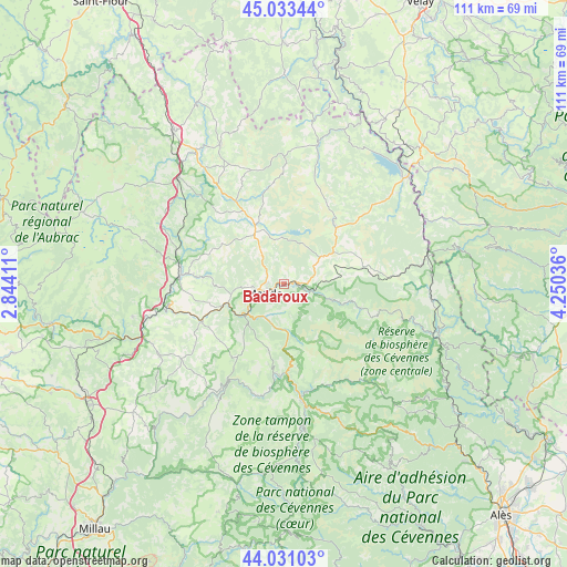
Badaroux GPS coordinates[2]
44° 32' 3.804" North, 3° 32' 50.064" East
| Map corner | latitude | longitude |
|---|---|---|
| Upper-left | 45.03344°, | 2.84411° |
| Center: | 44.53439°, | 3.54724° |
| Lower-right: | 44.03103°, | 4.25036° |
| Map W x H: | 111.5×111.5 km | = 69.3×69.3mi |
| max Lat: | 51.07786° ⇑83.3% North |
| Badaroux: | 44.53439° |
| min Lat: | ⇓16.7% South 41.3874° |
| min Long | Badaroux | max Long |
| -5.08615° | 3.54724° | 9.52242° |
| W 64.7%⇐ | ⇒35.3% E |
Elevation
Elevation of Badaroux is 783 m = 2569 ft, and this is 589.3 m = 1933 ft above average elevation for this country.
| Max E: |
2333 m = 7654 ft | 2.4% |
| Badaroux | 783 m 2569 ft | |
| Avg. | 193.7 m = 635 ft | |
Min E: |
-1 m = -3 ft | 97.6% |
See also: France elevation on elevation.city.
Geographical zone
Badaroux is located in North temperate zone (between Tropic of Cancer and the Arctic Circle). Distance of this Northern Tropic circle is 2345.8 km =1457.6 mi to South.| Distance of | km | miles | from Badaroux |
|---|---|---|---|
| North Pole | 5055.3 | 3141.2 | to North |
| Arctic Circle | 2449.4 | 1522 | to North |
| Tropic Cancer | 2345.8 | 1457.6 | to South |
| Equator | 4951.8 | 3076.9 | to South |


Nearby cities:
15 places around Badaroux: (largest is in red/bold)
• Balsièges
9.3 km =5.8 mi,  230°
230°
• Barjac
11.3 km =7 mi,  252°
252°
• Chanac
17.9 km =11.1 mi,  244°
244°
• Chastel-Nouvel
4.5 km =2.8 mi,  306°
306°
• Chirac
22.3 km =13.9 mi,  266°
266°
• Châteauneuf-de-Randon
15.6 km =9.7 mi,  40°
40°
• Florac
23.4 km =14.5 mi,  171°
171°
• Ispagnac
18.2 km =11.3 mi,  182°
182°
• Le Monastier-Pin-Moriès
23.6 km =14.7 mi, 265°
• Marvejols
20.4 km =12.7 mi,  276°
276°
• Mende
3.9 km =2.4 mi, 242°
• Montrodat
17.4 km =10.8 mi, 275°
• Rieutort-de-Randon
12.1 km =7.5 mi,  335°
335°
• Saint-Étienne-du-Valdonnez
8.8 km =5.5 mi, 171°
• Sainte-Enimie
21.3 km =13.2 mi,  209°
209°
Sources, notices
• [Note1] Compared only with cities in France existing in our database
• [Src1] Map data: © OpenStreetMap contributors (CC-BY-SA)
• [Src2] Other city data from geonames.org with taken over terms of usage.
• [Src3] Geographical zone / Annual Mean Temperature by Robert A. Rohde @ Wikipedia
