Manduel geodata
Manduel (Occitanie) is a populated place; located in France in Europe/Paris (GMT+2) time zone. With population of 6,260 people, there are 1584 cities with bigger population in this country. Compared to other cities in France, 88.9% of cities are located further ↑North; 71.9% of cities are located further ←West and 79% of cities have higher elevation than Manduel. Note1
Administrative division(s):
- Level 1: Occitanie
- Level 2: Gard
- Level 3: Arrondissement de Nîmes
- Level 4: Manduel


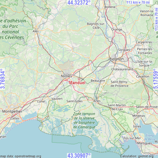
Manduel GPS coordinates[2]
43° 49' 6.78" North, 4° 28' 20.892" East
| Map corner | latitude | longitude |
|---|---|---|
| Upper-left | 44.32372°, | 3.76934° |
| Center: | 43.81855°, | 4.47247° |
| Lower-right: | 43.30907°, | 5.17559° |
| Map W x H: | 112.8×112.8 km | = 70.1×70.1mi |
| max Lat: | 51.07786° ⇑88.9% North |
| Manduel: | 43.81855° |
| min Lat: | ⇓11.1% South 41.3874° |
| min Long | Manduel | max Long |
| -5.08615° | 4.47247° | 9.52242° |
| W 71.9%⇐ | ⇒28.1% E |
Elevation
Elevation of Manduel is 57 m = 187 ft, and this is 136.7 m = 448 ft below average elevation for this country.
| Max E: |
2333 m = 7654 ft | 79% |
| Avg. | 193.7 m = 635 ft | |
| Manduel | 57 m = 187 ft | |
Min E: |
-1 m = -3 ft | 21% |
See also: France elevation on elevation.city.
Geographical zone
Manduel is located in North temperate zone (between Tropic of Cancer and the Arctic Circle). Distance of this Northern Tropic circle is 2266.2 km =1408.2 mi to South.| Distance of | km | miles | from Manduel |
|---|---|---|---|
| North Pole | 5134.9 | 3190.7 | to North |
| Arctic Circle | 2529 | 1571.4 | to North |
| Tropic Cancer | 2266.2 | 1408.2 | to South |
| Equator | 4872.2 | 3027.4 | to South |


Nearby cities:
15 places around Manduel: (largest is in red/bold)
• Bellegarde
8.1 km =5 mi,  154°
154°
• Bezouce
7.2 km =4.5 mi,  11°
11°
• Bouillargues
4.2 km =2.6 mi,  236°
236°
• Cabrières
9.5 km =5.9 mi,  359°
359°
• Caissargues
7.9 km =4.9 mi,  250°
250°
• Garons
6.6 km =4.1 mi,  213°
213°
• Jonquières-Saint-Vincent
7.4 km =4.6 mi,  81°
81°
• Lédenon
11.1 km =6.9 mi,  17°
17°
• Marguerittes
5.1 km =3.2 mi,  334°
334°
• Meynes
9.8 km =6.1 mi,  45°
45°
• Nîmes
9.2 km =5.7 mi,  280°
280°
• Poulx
10.9 km =6.8 mi,  335°
335°
• Redessan
2.5 km =1.6 mi,  55°
55°
• Rodilhan
3.5 km =2.2 mi,  286°
286°
• Saint-Gervasy
6.5 km =4 mi, 355°
Sources, notices
• [Note1] Compared only with cities in France existing in our database
• [Src1] Map data: © OpenStreetMap contributors (CC-BY-SA)
• [Src2] Other city data from geonames.org with taken over terms of usage.
• [Src3] Geographical zone / Annual Mean Temperature by Robert A. Rohde @ Wikipedia
