Quemper-Guézennec geodata
Quemper-Guézennec (Brittany) is a populated place; located in France in Europe/Paris (GMT+2) time zone. With population of 1,074 people, there are 8304 cities with bigger population in this country. Compared to other cities in France, 73.3% of cities are located further ↓South; 97.5% of cities are located further →East and 75.8% of cities have higher elevation than Quemper-Guézennec. Note1
Administrative division(s):
- Level 1: Brittany
- Level 2: Département des Côtes-d’Armor
- Level 3: Arrondissement de Guingamp
- Level 4: Quemper-Guézennec


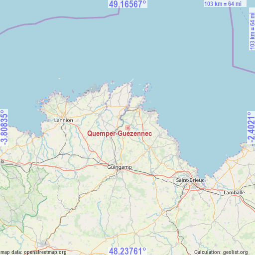
Quemper-Guézennec GPS coordinates[2]
48° 42' 13.608" North, 3° 6' 18.792" West
| Map corner | latitude | longitude |
|---|---|---|
| Upper-left | 49.16567°, | -3.80835° |
| Center: | 48.70378°, | -3.10522° |
| Lower-right: | 48.23761°, | -2.4021° |
| Map W x H: | 103.2×103.2 km | = 64.1×64.1mi |
| max Lat: | 51.07786° ⇑26.7% North |
| Quemper-Guézennec: | 48.70378° |
| min Lat: | ⇓73.3% South 41.3874° |
| min Long | Quemper-Guézen | max Long |
| -5.08615° | -3.10522° | 9.52242° |
| W 2.5%⇐ | ⇒97.5% E |
Elevation
Elevation of Quemper-Guézennec is 65 m = 213 ft, and this is 128.7 m = 422 ft below average elevation for this country.
| Max E: |
2333 m = 7654 ft | 75.8% |
| Avg. | 193.7 m = 635 ft | |
| Quemper-Guézennec | 65 m = 213 ft | |
Min E: |
-1 m = -3 ft | 24.2% |
See also: France elevation on elevation.city.
Geographical zone
Quemper-Guézennec is located in North temperate zone (between Tropic of Cancer and the Arctic Circle). Distance of this North polar circle is 1985.8 km =1233.9 mi to North.| Distance of | km | miles | from Quemper-Guézennec |
|---|---|---|---|
| North Pole | 4591.7 | 2853.1 | to North |
| Arctic Circle | 1985.8 | 1233.9 | to North |
| Tropic Cancer | 2809.4 | 1745.7 | to South |
| Equator | 5415.4 | 3365 | to South |


Nearby cities:
15 places around Quemper-Guézennec: (largest is in red/bold)
• Kerfot
6.8 km =4.2 mi,  56°
56°
• Lézardrieux
9 km =5.6 mi,  359°
359°
• Paimpol
9.4 km =5.8 mi,  28°
28°
• Pleudaniel
7.4 km =4.6 mi,  339°
339°
• Plourivo
5.3 km =3.3 mi, 28°
• Plouézec
10.3 km =6.4 mi, 59°
• Plouëc-du-Trieux
7.3 km =4.5 mi,  251°
251°
• Ploëzal
7.3 km =4.5 mi,  280°
280°
• Pléhédel
7.2 km =4.5 mi,  96°
96°
• Pommerit-Jaudy
10.5 km =6.5 mi,  286°
286°
• Pommerit-le-Vicomte
9.4 km =5.8 mi,  173°
173°
• Pontrieux
4 km =2.5 mi,  265°
265°
• Saint-Clet
4.8 km =3 mi,  205°
205°
• Squiffiec
9.1 km =5.7 mi,  203°
203°
• Yvias
4.1 km =2.5 mi,  73°
73°
Sources, notices
• [Note1] Compared only with cities in France existing in our database
• [Src1] Map data: © OpenStreetMap contributors (CC-BY-SA)
• [Src2] Other city data from geonames.org with taken over terms of usage.
• [Src3] Geographical zone / Annual Mean Temperature by Robert A. Rohde @ Wikipedia
