Plouézec geodata
Plouézec (Brittany) is a populated place; located in France in Europe/Paris (GMT+2) time zone. With population of 3,321 people, there are 2939 cities with bigger population in this country. Compared to other cities in France, 74.4% of cities are located further ↓South; 97.3% of cities are located further →East and 62.4% of cities have higher elevation than Plouézec. Note1
Administrative division(s):
- Level 1: Brittany
- Level 2: Département des Côtes-d’Armor
- Level 3: Arrondissement de Guingamp
- Level 4: Plouézec


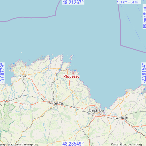
Plouézec GPS coordinates[2]
48° 45' 4.392" North, 2° 59' 4.812" West
| Map corner | latitude | longitude |
|---|---|---|
| Upper-left | 49.21267°, | -3.68779° |
| Center: | 48.75122°, | -2.98467° |
| Lower-right: | 48.28549°, | -2.28154° |
| Map W x H: | 103.1×103.1 km | = 64.1×64.1mi |
| max Lat: | 51.07786° ⇑25.6% North |
| Plouézec: | 48.75122° |
| min Lat: | ⇓74.4% South 41.3874° |
| min Long | Plouézec | max Long |
| -5.08615° | -2.98467° | 9.52242° |
| W 2.7%⇐ | ⇒97.3% E |
Elevation
Elevation of Plouézec is 96 m = 315 ft, and this is 97.7 m = 321 ft below average elevation for this country.
| Max E: |
2333 m = 7654 ft | 62.4% |
| Avg. | 193.7 m = 635 ft | |
| Plouézec | 96 m = 315 ft | |
Min E: |
-1 m = -3 ft | 37.6% |
See also: France elevation on elevation.city.
Geographical zone
Plouézec is located in North temperate zone (between Tropic of Cancer and the Arctic Circle). Distance of this North polar circle is 1980.5 km =1230.6 mi to North.| Distance of | km | miles | from Plouézec |
|---|---|---|---|
| North Pole | 4586.4 | 2849.9 | to North |
| Arctic Circle | 1980.5 | 1230.6 | to North |
| Tropic Cancer | 2814.7 | 1749 | to South |
| Equator | 5420.6 | 3368.2 | to South |


Nearby cities:
15 places around Plouézec: (largest is in red/bold)
• Kerfot
3.6 km =2.2 mi,  244°
244°
• Lanvollon
13.3 km =8.3 mi,  180°
180°
• Lézardrieux
9.6 km =6 mi,  292°
292°
• Paimpol
5.3 km =3.3 mi,  304°
304°
• Pleudaniel
11.5 km =7.1 mi,  278°
278°
• Pleumeur-Gautier
13.7 km =8.5 mi, 293°
• Ploubazlanec
6.5 km =4 mi,  326°
326°
• Plouha
9.3 km =5.8 mi,  153°
153°
• Plourivo
6.3 km =3.9 mi,  264°
264°
• Pléguien
13.3 km =8.3 mi,  165°
165°
• Pléhédel
6.3 km =3.9 mi,  195°
195°
• Pontrieux
14 km =8.7 mi,  246°
246°
• Quemper-Guézennec
10.3 km =6.4 mi, 239°
• Tréveneuc
12.8 km =8 mi,  138°
138°
• Yvias
6.4 km =4 mi,  230°
230°
Sources, notices
• [Note1] Compared only with cities in France existing in our database
• [Src1] Map data: © OpenStreetMap contributors (CC-BY-SA)
• [Src2] Other city data from geonames.org with taken over terms of usage.
• [Src3] Geographical zone / Annual Mean Temperature by Robert A. Rohde @ Wikipedia
