Pléhédel geodata
Pléhédel (Brittany) is a populated place; located in France in Europe/Paris (GMT+2) time zone. With population of 1,180 people, there are 7645 cities with bigger population in this country. Compared to other cities in France, 73.1% of cities are located further ↓South; 97.3% of cities are located further →East and 62.4% of cities have higher elevation than Pléhédel. Note1
Administrative division(s):
- Level 1: Brittany
- Level 2: Département des Côtes-d’Armor
- Level 3: Arrondissement de Guingamp
- Level 4: Pléhédel


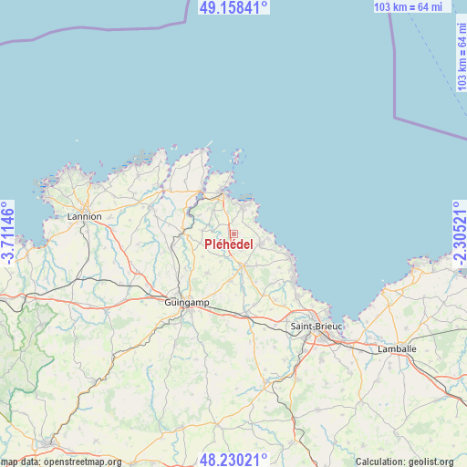
Pléhédel GPS coordinates[2]
48° 41' 47.22" North, 3° 0' 29.988" West
| Map corner | latitude | longitude |
|---|---|---|
| Upper-left | 49.15841°, | -3.71146° |
| Center: | 48.69645°, | -3.00833° |
| Lower-right: | 48.23021°, | -2.30521° |
| Map W x H: | 103.2×103.2 km | = 64.1×64.1mi |
| max Lat: | 51.07786° ⇑26.9% North |
| Pléhédel: | 48.69645° |
| min Lat: | ⇓73.1% South 41.3874° |
| min Long | Pléhédel | max Long |
| -5.08615° | -3.00833° | 9.52242° |
| W 2.7%⇐ | ⇒97.3% E |
Elevation
Elevation of Pléhédel is 96 m = 315 ft, and this is 97.7 m = 321 ft below average elevation for this country.
| Max E: |
2333 m = 7654 ft | 62.4% |
| Avg. | 193.7 m = 635 ft | |
| Pléhédel | 96 m = 315 ft | |
Min E: |
-1 m = -3 ft | 37.6% |
See also: France elevation on elevation.city.
Geographical zone
Pléhédel is located in North temperate zone (between Tropic of Cancer and the Arctic Circle). Distance of this North polar circle is 1986.6 km =1234.4 mi to North.| Distance of | km | miles | from Pléhédel |
|---|---|---|---|
| North Pole | 4592.5 | 2853.6 | to North |
| Arctic Circle | 1986.6 | 1234.4 | to North |
| Tropic Cancer | 2808.6 | 1745.2 | to South |
| Equator | 5414.5 | 3364.4 | to South |


Nearby cities:
15 places around Pléhédel: (largest is in red/bold)
• Goudelin
10.3 km =6.4 mi,  184°
184°
• Kerfot
4.8 km =3 mi,  341°
341°
• Lanvollon
7.4 km =4.6 mi,  167°
167°
• Paimpol
9.5 km =5.9 mi, 344°
• Plouha
6.3 km =3.9 mi,  110°
110°
• Plourivo
7.1 km =4.4 mi,  319°
319°
• Plouézec
6.3 km =3.9 mi,  15°
15°
• Pléguien
8.5 km =5.3 mi,  143°
143°
• Pommerit-le-Vicomte
10.4 km =6.5 mi,  215°
215°
• Pontrieux
11.1 km =6.9 mi,  272°
272°
• Quemper-Guézennec
7.2 km =4.5 mi,  276°
276°
• Saint-Clet
9.8 km =6.1 mi,  249°
249°
• Tressignaux
9 km =5.6 mi, 169°
• Tréveneuc
10.8 km =6.7 mi, 108°
• Yvias
3.8 km =2.4 mi,  301°
301°
Sources, notices
• [Note1] Compared only with cities in France existing in our database
• [Src1] Map data: © OpenStreetMap contributors (CC-BY-SA)
• [Src2] Other city data from geonames.org with taken over terms of usage.
• [Src3] Geographical zone / Annual Mean Temperature by Robert A. Rohde @ Wikipedia
