Quarré-les-Tombes geodata
Quarré-les-Tombes (Bourgogne-Franche-Comté) is a populated place; located in France in Europe/Paris (GMT+2) time zone. With population of 754 people, there are 11124 cities with bigger population in this country. Compared to other cities in France, 50.5% of cities are located further ↑North; 67.8% of cities are located further ←West and 91.4% of cities have lower elevation than Quarré-les-Tombes. Note1
Administrative division(s):
- Level 1: Bourgogne-Franche-Comté
- Level 2: Département de l'Yonne
- Level 3: Avallon
- Level 4: Quarré-les-Tombes


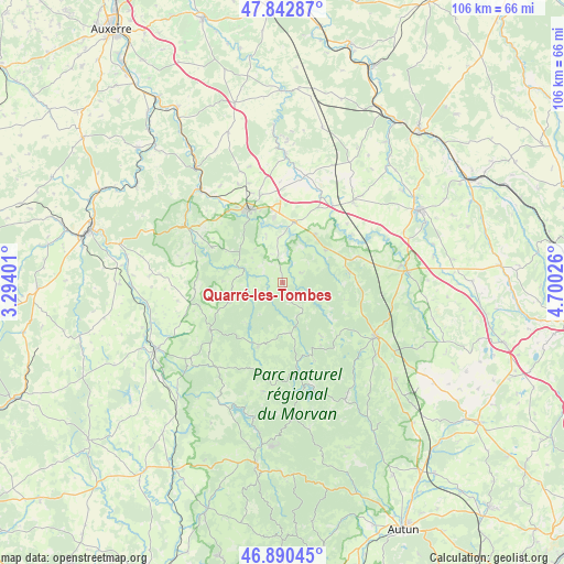
Quarré-les-Tombes GPS coordinates[2]
47° 22' 7.716" North, 3° 59' 49.668" East
| Map corner | latitude | longitude |
|---|---|---|
| Upper-left | 47.84287°, | 3.29401° |
| Center: | 47.36881°, | 3.99713° |
| Lower-right: | 46.89045°, | 4.70026° |
| Map W x H: | 105.9×105.9 km | = 65.8×65.8mi |
| max Lat: | 51.07786° ⇑50.5% North |
| Quarré-les-Tombes: | 47.36881° |
| min Lat: | ⇓49.5% South 41.3874° |
| min Long | Quarré-les-Tom | max Long |
| -5.08615° | 3.99713° | 9.52242° |
| W 67.8%⇐ | ⇒32.2% E |
Elevation
Elevation of Quarré-les-Tombes is 459 m = 1506 ft, and this is 265.3 m = 870 ft above average elevation for this country.
| Max E: |
2333 m = 7654 ft | 8.6% |
| Quarré-les-Tombes | 459 m 1506 ft | |
| Avg. | 193.7 m = 635 ft | |
Min E: |
-1 m = -3 ft | 91.4% |
See also: France elevation on elevation.city.
Geographical zone
Quarré-les-Tombes is located in North temperate zone (between Tropic of Cancer and the Arctic Circle). Distance of this North polar circle is 2134.3 km =1326.2 mi to North.| Distance of | km | miles | from Quarré-les-Tombes |
|---|---|---|---|
| North Pole | 4740.1 | 2945.4 | to North |
| Arctic Circle | 2134.3 | 1326.2 | to North |
| Tropic Cancer | 2661 | 1653.5 | to South |
| Equator | 5266.9 | 3272.7 | to South |


Nearby cities:
15 places around Quarré-les-Tombes: (largest is in red/bold)
• Alligny-en-Morvan
23.2 km =14.4 mi,  144°
144°
• Avallon
15 km =9.3 mi,  333°
333°
• Brassy
12.8 km =8 mi,  201°
201°
• Cervon
23.1 km =14.4 mi,  231°
231°
• Corbigny
26.8 km =16.7 mi,  242°
242°
• La Roche-en-Brenil
13.8 km =8.6 mi,  84°
84°
• Lormes
16.2 km =10.1 mi, 237°
• Montsauche-les-Settons
17 km =10.6 mi,  175°
175°
• Ouroux-en-Morvan
20.9 km =13 mi,  189°
189°
• Précy-sous-Thil
23.5 km =14.6 mi, 84°
• Rouvray
10.2 km =6.3 mi,  52°
52°
• Saulieu
20 km =12.4 mi,  119°
119°
• Sauvigny-le-Bois
16.7 km =10.4 mi,  345°
345°
• Vézelay
21.8 km =13.5 mi,  299°
299°
• Époisses
20.3 km =12.6 mi,  40°
40°
Sources, notices
• [Note1] Compared only with cities in France existing in our database
• [Src1] Map data: © OpenStreetMap contributors (CC-BY-SA)
• [Src2] Other city data from geonames.org with taken over terms of usage.
• [Src3] Geographical zone / Annual Mean Temperature by Robert A. Rohde @ Wikipedia
