Avallon geodata
Avallon (Bourgogne-Franche-Comté) is a seat of a third-order administrative division; located in France in Europe/Paris (GMT+2) time zone. With population of 8,740 people, there are 1098 cities with bigger population in this country. Compared to other cities in France, 51.1% of cities are located further ↓South; 67% of cities are located further ←West and 74.6% of cities have lower elevation than Avallon. Note1
Administrative division(s):
- Level 1: Bourgogne-Franche-Comté
- Level 2: Département de l'Yonne
- Level 3: Avallon
- Level 4: Avallon


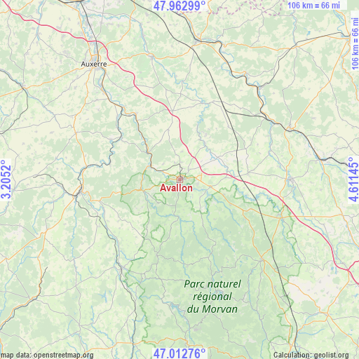
Avallon GPS coordinates[2]
47° 29' 24.072" North, 3° 54' 29.952" East
| Map corner | latitude | longitude |
|---|---|---|
| Upper-left | 47.96299°, | 3.2052° |
| Center: | 47.49002°, | 3.90832° |
| Lower-right: | 47.01276°, | 4.61145° |
| Map W x H: | 105.7×105.7 km | = 65.7×65.7mi |
| max Lat: | 51.07786° ⇑48.9% North |
| Avallon: | 47.49002° |
| min Lat: | ⇓51.1% South 41.3874° |
| min Long | Avallon | max Long |
| -5.08615° | 3.90832° | 9.52242° |
| W 67%⇐ | ⇒33% E |
Elevation
Elevation of Avallon is 246 m = 807 ft, and this is 52.3 m = 172 ft above average elevation for this country.
| Max E: |
2333 m = 7654 ft | 25.4% |
| Avallon | 246 m 807 ft | |
| Avg. | 193.7 m = 635 ft | |
Min E: |
-1 m = -3 ft | 74.6% |
See also: France elevation on elevation.city.
Geographical zone
Avallon is located in North temperate zone (between Tropic of Cancer and the Arctic Circle). Distance of this North polar circle is 2120.8 km =1317.8 mi to North.| Distance of | km | miles | from Avallon |
|---|---|---|---|
| North Pole | 4726.7 | 2937 | to North |
| Arctic Circle | 2120.8 | 1317.8 | to North |
| Tropic Cancer | 2674.5 | 1661.9 | to South |
| Equator | 5280.4 | 3281.1 | to South |


Nearby cities:
15 places around Avallon: (largest is in red/bold)
• Brassy
25.4 km =15.8 mi,  175°
175°
• Châtel-Censoir
21.2 km =13.2 mi,  283°
283°
• Dornecy
25.1 km =15.6 mi,  256°
256°
• Joux-la-Ville
15.1 km =9.4 mi,  346°
346°
• La Roche-en-Brenil
23.7 km =14.7 mi,  120°
120°
• Lormes
23.3 km =14.5 mi,  197°
197°
• Mailly-la-Ville
21 km =13 mi,  306°
306°
• Mailly-le-Château
23.6 km =14.7 mi,  300°
300°
• Noyers
23.7 km =14.7 mi,  15°
15°
• Quarré-les-Tombes
15 km =9.3 mi,  153°
153°
• Rouvray
16.5 km =10.3 mi, 116°
• Sauvigny-le-Bois
3.6 km =2.2 mi,  42°
42°
• Vermenton
23.4 km =14.5 mi,  326°
326°
• Vézelay
12.5 km =7.8 mi, 257°
• Époisses
20.1 km =12.5 mi,  84°
84°
Sources, notices
• [Note1] Compared only with cities in France existing in our database
• [Src1] Map data: © OpenStreetMap contributors (CC-BY-SA)
• [Src2] Other city data from geonames.org with taken over terms of usage.
• [Src3] Geographical zone / Annual Mean Temperature by Robert A. Rohde @ Wikipedia
