Alligny-en-Morvan geodata
Alligny-en-Morvan (Bourgogne-Franche-Comté) is a populated place; located in France in Europe/Paris (GMT+2) time zone. With population of 651 people, there are 12511 cities with bigger population in this country. Compared to other cities in France, 53% of cities are located further ↑North; 69.5% of cities are located further ←West and 91.2% of cities have lower elevation than Alligny-en-Morvan. Note1
Administrative division(s):
- Level 1: Bourgogne-Franche-Comté
- Level 2: Département de la Nièvre
- Level 3: Arrondissement de Château-Chinon (Ville)
- Level 4: Alligny-en-Morvan


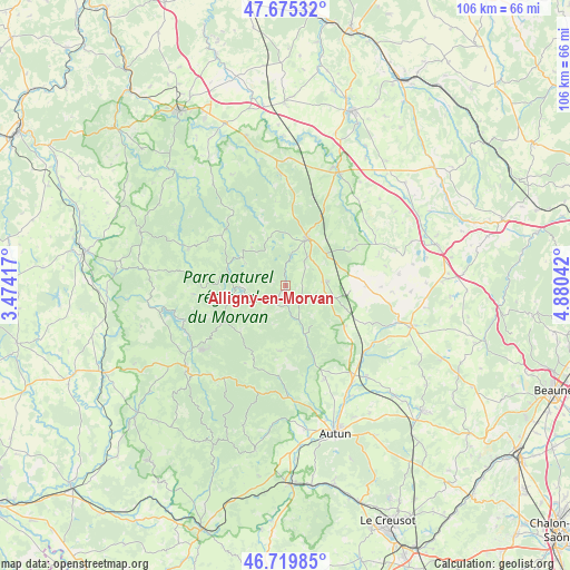
Alligny-en-Morvan GPS coordinates[2]
47° 11' 59.064" North, 4° 10' 38.244" East
| Map corner | latitude | longitude |
|---|---|---|
| Upper-left | 47.67532°, | 3.47417° |
| Center: | 47.19974°, | 4.17729° |
| Lower-right: | 46.71985°, | 4.88042° |
| Map W x H: | 106.2×106.2 km | = 66×66mi |
| max Lat: | 51.07786° ⇑53% North |
| Alligny-en-Morvan: | 47.19974° |
| min Lat: | ⇓47% South 41.3874° |
| min Long | Alligny-en-Morv | max Long |
| -5.08615° | 4.17729° | 9.52242° |
| W 69.5%⇐ | ⇒30.5% E |
Elevation
Elevation of Alligny-en-Morvan is 454 m = 1490 ft, and this is 260.3 m = 854 ft above average elevation for this country.
| Max E: |
2333 m = 7654 ft | 8.8% |
| Alligny-en-Morvan | 454 m 1490 ft | |
| Avg. | 193.7 m = 635 ft | |
Min E: |
-1 m = -3 ft | 91.2% |
See also: France elevation on elevation.city.
Geographical zone
Alligny-en-Morvan is located in North temperate zone (between Tropic of Cancer and the Arctic Circle). Distance of this North polar circle is 2153.1 km =1337.9 mi to North.| Distance of | km | miles | from Alligny-en-Morvan |
|---|---|---|---|
| North Pole | 4758.9 | 2957 | to North |
| Arctic Circle | 2153.1 | 1337.9 | to North |
| Tropic Cancer | 2642.2 | 1641.8 | to South |
| Equator | 5248.1 | 3261 | to South |


Nearby cities:
15 places around Alligny-en-Morvan: (largest is in red/bold)
• Anost
14.8 km =9.2 mi,  203°
203°
• Arleuf
20.9 km =13 mi,  214°
214°
• Brassy
19.6 km =12.2 mi,  290°
290°
• Château-Chinon(Ville)
23.7 km =14.7 mi,  231°
231°
• Dracy-Saint-Loup
24 km =14.9 mi,  148°
148°
• Igornay
22.9 km =14.2 mi,  138°
138°
• La Roche-en-Brenil
20.2 km =12.6 mi,  0°
0°
• Liernais
7.9 km =4.9 mi,  84°
84°
• Montsauche-les-Settons
12.3 km =7.6 mi,  278°
278°
• Ouroux-en-Morvan
17.3 km =10.7 mi,  263°
263°
• Précy-sous-Thil
23.3 km =14.5 mi,  25°
25°
• Quarré-les-Tombes
23.2 km =14.4 mi,  324°
324°
• Saint-Forgeot
23.7 km =14.7 mi,  156°
156°
• Saulieu
9.8 km =6.1 mi,  23°
23°
• Tavernay
21.1 km =13.1 mi,  168°
168°
Sources, notices
• [Note1] Compared only with cities in France existing in our database
• [Src1] Map data: © OpenStreetMap contributors (CC-BY-SA)
• [Src2] Other city data from geonames.org with taken over terms of usage.
• [Src3] Geographical zone / Annual Mean Temperature by Robert A. Rohde @ Wikipedia
