Puisserguier geodata
Puisserguier (Occitanie) is a populated place; located in France in Europe/Paris (GMT+2) time zone. With population of 2,666 people, there are 3662 cities with bigger population in this country. Compared to other cities in France, 94.6% of cities are located further ↑North; 58.4% of cities are located further ←West and 66.6% of cities have higher elevation than Puisserguier. Note1
Administrative division(s):
- Level 1: Occitanie
- Level 2: Département de l'Hérault
- Level 3: Arrondissement de Béziers
- Level 4: Puisserguier


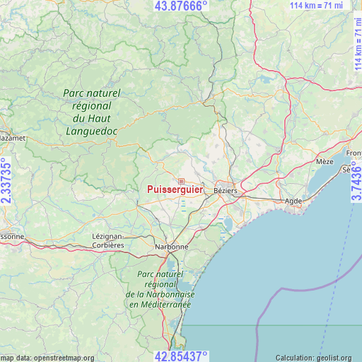
Puisserguier GPS coordinates[2]
43° 22' 3.612" North, 3° 2' 25.692" East
| Map corner | latitude | longitude |
|---|---|---|
| Upper-left | 43.87666°, | 2.33735° |
| Center: | 43.36767°, | 3.04047° |
| Lower-right: | 42.85437°, | 3.7436° |
| Map W x H: | 113.7×113.7 km | = 70.6×70.6mi |
| max Lat: | 51.07786° ⇑94.6% North |
| Puisserguier: | 43.36767° |
| min Lat: | ⇓5.4% South 41.3874° |
| min Long | Puisserguier | max Long |
| -5.08615° | 3.04047° | 9.52242° |
| W 58.4%⇐ | ⇒41.6% E |
Elevation
Elevation of Puisserguier is 86 m = 282 ft, and this is 107.7 m = 353 ft below average elevation for this country.
| Max E: |
2333 m = 7654 ft | 66.6% |
| Avg. | 193.7 m = 635 ft | |
| Puisserguier | 86 m = 282 ft | |
Min E: |
-1 m = -3 ft | 33.4% |
See also: France elevation on elevation.city.
Geographical zone
Puisserguier is located in North temperate zone (between Tropic of Cancer and the Arctic Circle). Distance of this Northern Tropic circle is 2216.1 km =1377 mi to South.| Distance of | km | miles | from Puisserguier |
|---|---|---|---|
| North Pole | 5185 | 3221.8 | to North |
| Arctic Circle | 2579.1 | 1602.6 | to North |
| Tropic Cancer | 2216.1 | 1377 | to South |
| Equator | 4822 | 2996.3 | to South |


Nearby cities:
15 places around Puisserguier: (largest is in red/bold)
• Capestang
4.4 km =2.7 mi,  175°
175°
• Cazouls-lès-Béziers
5.6 km =3.5 mi,  60°
60°
• Cessenon-sur-Orb
9.2 km =5.7 mi,  5°
5°
• Colombiers
10 km =6.2 mi,  126°
126°
• Creissan
2.5 km =1.6 mi,  290°
290°
• Cruzy
8.2 km =5.1 mi,  260°
260°
• Lignan-sur-Orb
10.6 km =6.6 mi,  79°
79°
• Maraussan
9.4 km =5.8 mi,  89°
89°
• Maureilhan
6.5 km =4 mi,  107°
107°
• Montady
7.9 km =4.9 mi,  116°
116°
• Murviel-lès-Béziers
10.5 km =6.5 mi,  45°
45°
• Nissan-lez-Enserune
11.2 km =7 mi,  141°
141°
• Ouveillan
10.4 km =6.5 mi,  212°
212°
• Quarante
6.7 km =4.2 mi,  250°
250°
• Saint-Chinian
9.7 km =6 mi,  308°
308°
Sources, notices
• [Note1] Compared only with cities in France existing in our database
• [Src1] Map data: © OpenStreetMap contributors (CC-BY-SA)
• [Src2] Other city data from geonames.org with taken over terms of usage.
• [Src3] Geographical zone / Annual Mean Temperature by Robert A. Rohde @ Wikipedia
