Guillaumes geodata
Guillaumes (Provence-Alpes-Côte d'Azur) is a populated place; located in France in Europe/Paris (GMT+2) time zone. With population of 613 people, there are 13109 cities with bigger population in this country. Compared to other cities in France, 86.3% of cities are located further ↑North; 94% of cities are located further ←West and 98.9% of cities have lower elevation than Guillaumes. Note1
Administrative division(s):
- Level 1: Provence-Alpes-Côte d'Azur
- Level 2: Alpes-Maritimes
- Level 3: Arrondissement de Nice
- Level 4: Guillaumes


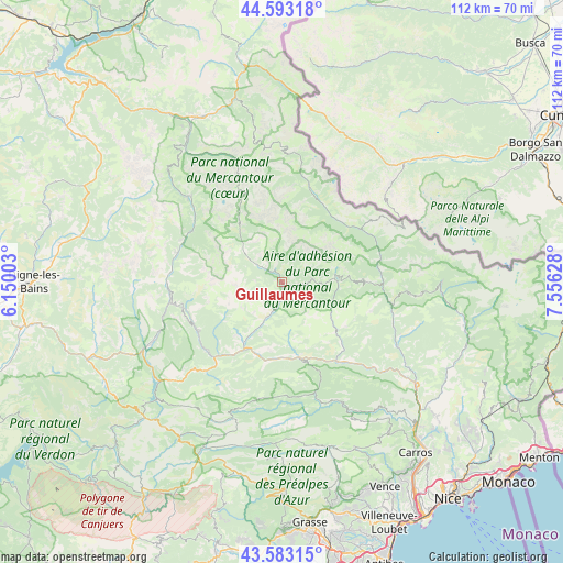
Guillaumes GPS coordinates[2]
44° 5' 25.152" North, 6° 51' 11.34" East
| Map corner | latitude | longitude |
|---|---|---|
| Upper-left | 44.59318°, | 6.15003° |
| Center: | 44.09032°, | 6.85315° |
| Lower-right: | 43.58315°, | 7.55628° |
| Map W x H: | 112.3×112.3 km | = 69.8×69.8mi |
| max Lat: | 51.07786° ⇑86.3% North |
| Guillaumes: | 44.09032° |
| min Lat: | ⇓13.7% South 41.3874° |
| min Long | Guillaumes | max Long |
| -5.08615° | 6.85315° | 9.52242° |
| W 94%⇐ | ⇒6% E |
Elevation
Elevation of Guillaumes is 945 m = 3100 ft, and this is 751.3 m = 2465 ft above average elevation for this country.
| Max E: |
2333 m = 7654 ft | 1.1% |
| Guillaumes | 945 m 3100 ft | |
| Avg. | 193.7 m = 635 ft | |
Min E: |
-1 m = -3 ft | 98.9% |
See also: France elevation on elevation.city.
Geographical zone
Guillaumes is located in North temperate zone (between Tropic of Cancer and the Arctic Circle). Distance of this Northern Tropic circle is 2296.5 km =1427 mi to South.| Distance of | km | miles | from Guillaumes |
|---|---|---|---|
| North Pole | 5104.7 | 3171.9 | to North |
| Arctic Circle | 2498.8 | 1552.7 | to North |
| Tropic Cancer | 2296.5 | 1427 | to South |
| Equator | 4902.4 | 3046.2 | to South |


Nearby cities:
15 places around Guillaumes: (largest is in red/bold)
• Allos
24.5 km =15.2 mi,  313°
313°
• Annot
20.3 km =12.6 mi,  226°
226°
• Barcelonnette
36.7 km =22.8 mi,  334°
334°
• Clans
25.8 km =16 mi,  114°
114°
• Enchastrayes
33.3 km =20.7 mi,  337°
337°
• Entrevaux
16 km =9.9 mi,  192°
192°
• Gilette
36.5 km =22.7 mi,  137°
137°
• Isola
19.1 km =11.9 mi,  56°
56°
• Puget-Théniers
15.3 km =9.5 mi,  167°
167°
• Péone
5.2 km =3.2 mi, 55°
• Roquesteron
27.5 km =17.1 mi,  154°
154°
• Saint-André-les-Alpes
30.8 km =19.1 mi,  243°
243°
• Saint-Martin-Vésubie
32.3 km =20.1 mi,  94°
94°
• Saint-Étienne-de-Tinée
19.3 km =12 mi,  17°
17°
• Villars-sur-Var
25.9 km =16.1 mi,  131°
131°
Sources, notices
• [Note1] Compared only with cities in France existing in our database
• [Src1] Map data: © OpenStreetMap contributors (CC-BY-SA)
• [Src2] Other city data from geonames.org with taken over terms of usage.
• [Src3] Geographical zone / Annual Mean Temperature by Robert A. Rohde @ Wikipedia
