Preures geodata
Preures (Hauts-de-France) is a populated place; located in France in Europe/Paris (GMT+2) time zone. With population of 504 people, there are 15167 cities with bigger population in this country. Compared to other cities in France, 97.9% of cities are located further ↓South; 58.5% of cities are located further →East and 71% of cities have higher elevation than Preures. Note1
Administrative division(s):
- Level 1: Hauts-de-France
- Level 2: Pas-de-Calais
- Level 3: Arrondissement de Montreuil
- Level 4: Preures


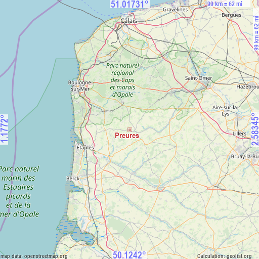
Preures GPS coordinates[2]
50° 34' 22.332" North, 1° 52' 49.152" East
| Map corner | latitude | longitude |
|---|---|---|
| Upper-left | 51.01731°, | 1.1772° |
| Center: | 50.57287°, | 1.88032° |
| Lower-right: | 50.1242°, | 2.58345° |
| Map W x H: | 99.3×99.3 km | = 61.7×61.7mi |
| max Lat: | 51.07786° ⇑2.1% North |
| Preures: | 50.57287° |
| min Lat: | ⇓97.9% South 41.3874° |
| min Long | Preures | max Long |
| -5.08615° | 1.88032° | 9.52242° |
| W 41.5%⇐ | ⇒58.5% E |
Elevation
Elevation of Preures is 76 m = 249 ft, and this is 117.7 m = 386 ft below average elevation for this country.
| Max E: |
2333 m = 7654 ft | 71% |
| Avg. | 193.7 m = 635 ft | |
| Preures | 76 m = 249 ft | |
Min E: |
-1 m = -3 ft | 29% |
See also: France elevation on elevation.city.
Geographical zone
Preures is located in North temperate zone (between Tropic of Cancer and the Arctic Circle). Distance of this North polar circle is 1778 km =1104.8 mi to North.| Distance of | km | miles | from Preures |
|---|---|---|---|
| North Pole | 4383.9 | 2724 | to North |
| Arctic Circle | 1778 | 1104.8 | to North |
| Tropic Cancer | 3017.3 | 1874.9 | to South |
| Equator | 5623.2 | 3494.1 | to South |


Nearby cities:
15 places around Preures: (largest is in red/bold)
• Attin
13.5 km =8.4 mi,  224°
224°
• Bourthes
5.2 km =3.2 mi,  46°
46°
• Bréxent-Énocq
12.6 km =7.8 mi,  236°
236°
• Campagne-lès-Boulonnais
9.2 km =5.7 mi,  61°
61°
• Courset
8.6 km =5.3 mi,  341°
341°
• Desvres
11.1 km =6.9 mi, 343°
• Frencq
12.9 km =8 mi,  263°
263°
• Hucqueliers
1.9 km =1.2 mi,  105°
105°
• Longfossé
10.2 km =6.3 mi,  329°
329°
• Menneville
11.8 km =7.3 mi,  355°
355°
• Neuville-sous-Montreuil
13.1 km =8.1 mi,  213°
213°
• Samer
11.9 km =7.4 mi,  307°
307°
• Thiembronne
13.7 km =8.5 mi,  66°
66°
• Verchocq
11.4 km =7.1 mi,  94°
94°
• Wailly
14.4 km =8.9 mi, 112°
Sources, notices
• [Note1] Compared only with cities in France existing in our database
• [Src1] Map data: © OpenStreetMap contributors (CC-BY-SA)
• [Src2] Other city data from geonames.org with taken over terms of usage.
• [Src3] Geographical zone / Annual Mean Temperature by Robert A. Rohde @ Wikipedia
