Bourthes geodata
Bourthes (Hauts-de-France) is a populated place; located in France in Europe/Paris (GMT+2) time zone. With population of 553 people, there are 14157 cities with bigger population in this country. Compared to other cities in France, 98.1% of cities are located further ↓South; 57.9% of cities are located further →East and 52.6% of cities have higher elevation than Bourthes. Note1
Administrative division(s):
- Level 1: Hauts-de-France
- Level 2: Pas-de-Calais
- Level 3: Arrondissement de Montreuil
- Level 4: Bourthes


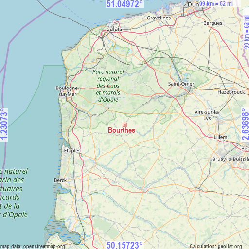
Bourthes GPS coordinates[2]
50° 36' 20.124" North, 1° 56' 1.86" East
| Map corner | latitude | longitude |
|---|---|---|
| Upper-left | 51.04972°, | 1.23073° |
| Center: | 50.60559°, | 1.93385° |
| Lower-right: | 50.15723°, | 2.63698° |
| Map W x H: | 99.2×99.2 km | = 61.6×61.6mi |
| max Lat: | 51.07786° ⇑1.9% North |
| Bourthes: | 50.60559° |
| min Lat: | ⇓98.1% South 41.3874° |
| min Long | Bourthes | max Long |
| -5.08615° | 1.93385° | 9.52242° |
| W 42.1%⇐ | ⇒57.9% E |
Elevation
Elevation of Bourthes is 123 m = 404 ft, and this is 70.7 m = 232 ft below average elevation for this country.
| Max E: |
2333 m = 7654 ft | 52.6% |
| Avg. | 193.7 m = 635 ft | |
| Bourthes | 123 m = 404 ft | |
Min E: |
-1 m = -3 ft | 47.4% |
See also: France elevation on elevation.city.
Geographical zone
Bourthes is located in North temperate zone (between Tropic of Cancer and the Arctic Circle). Distance of this North polar circle is 1774.4 km =1102.6 mi to North.| Distance of | km | miles | from Bourthes |
|---|---|---|---|
| North Pole | 4380.2 | 2721.7 | to North |
| Arctic Circle | 1774.4 | 1102.6 | to North |
| Tropic Cancer | 3020.9 | 1877.1 | to South |
| Equator | 5626.8 | 3496.3 | to South |


Nearby cities:
15 places around Bourthes: (largest is in red/bold)
• Campagne-lès-Boulonnais
4.4 km =2.7 mi,  79°
79°
• Courset
7.9 km =4.9 mi,  304°
304°
• Desvres
9.9 km =6.2 mi,  315°
315°
• Fauquembergues
11.7 km =7.3 mi,  92°
92°
• Hucqueliers
4.6 km =2.9 mi,  205°
205°
• Longfossé
10.3 km =6.4 mi, 300°
• Menneville
9.4 km =5.8 mi,  329°
329°
• Merck-Saint-Liévin
13 km =8.1 mi, 80°
• Nielles-lès-Bléquin
10.3 km =6.4 mi,  42°
42°
• Preures
5.2 km =3.2 mi,  226°
226°
• Quesques
10.9 km =6.8 mi,  359°
359°
• Seninghem
12.8 km =8 mi,  32°
32°
• Thiembronne
9 km =5.6 mi, 78°
• Verchocq
8.9 km =5.5 mi,  121°
121°
• Wismes
11.1 km =6.9 mi,  60°
60°
Sources, notices
• [Note1] Compared only with cities in France existing in our database
• [Src1] Map data: © OpenStreetMap contributors (CC-BY-SA)
• [Src2] Other city data from geonames.org with taken over terms of usage.
• [Src3] Geographical zone / Annual Mean Temperature by Robert A. Rohde @ Wikipedia
