Chaumes-en-Brie geodata
Chaumes-en-Brie (Île-de-France) is a populated place; located in France in Europe/Paris (GMT+2) time zone. With population of 3,100 people, there are 3148 cities with bigger population in this country. Compared to other cities in France, 72.5% of cities are located further ↓South; 55.6% of cities are located further ←West and 60.4% of cities have higher elevation than Chaumes-en-Brie. Note1
Administrative division(s):
- Level 1: Île-de-France
- Level 2: Seine-et-Marne
- Level 3: Arrondissement de Melun
- Level 4: Chaumes-en-Brie


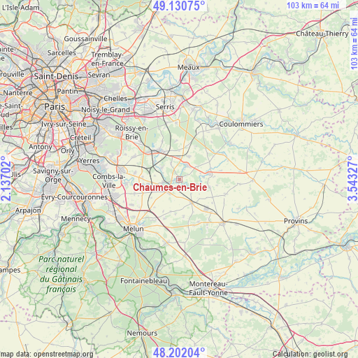
Chaumes-en-Brie GPS coordinates[2]
48° 40' 6.708" North, 2° 50' 24.54" East
| Map corner | latitude | longitude |
|---|---|---|
| Upper-left | 49.13075°, | 2.13702° |
| Center: | 48.66853°, | 2.84015° |
| Lower-right: | 48.20204°, | 3.54327° |
| Map W x H: | 103.3×103.3 km | = 64.2×64.2mi |
| max Lat: | 51.07786° ⇑27.5% North |
| Chaumes-en-Brie: | 48.66853° |
| min Lat: | ⇓72.5% South 41.3874° |
| min Long | Chaumes-en-Brie | max Long |
| -5.08615° | 2.84015° | 9.52242° |
| W 55.6%⇐ | ⇒44.4% E |
Elevation
Elevation of Chaumes-en-Brie is 101 m = 331 ft, and this is 92.7 m = 304 ft below average elevation for this country.
| Max E: |
2333 m = 7654 ft | 60.4% |
| Avg. | 193.7 m = 635 ft | |
| Chaumes-en-Brie | 101 m = 331 ft | |
Min E: |
-1 m = -3 ft | 39.6% |
See also: France elevation on elevation.city.
Geographical zone
Chaumes-en-Brie is located in North temperate zone (between Tropic of Cancer and the Arctic Circle). Distance of this North polar circle is 1989.7 km =1236.3 mi to North.| Distance of | km | miles | from Chaumes-en-Brie |
|---|---|---|---|
| North Pole | 4595.6 | 2855.6 | to North |
| Arctic Circle | 1989.7 | 1236.3 | to North |
| Tropic Cancer | 2805.5 | 1743.3 | to South |
| Equator | 5411.4 | 3362.5 | to South |


Nearby cities:
15 places around Chaumes-en-Brie: (largest is in red/bold)
• Aubepierre-Ozouer-le-Repos
5 km =3.1 mi,  140°
140°
• Bernay-Vilbert
7.2 km =4.5 mi,  82°
82°
• Châtres
5.1 km =3.2 mi,  334°
334°
• Courpalay
9.1 km =5.7 mi,  103°
103°
• Courtomer
5 km =3.1 mi,  110°
110°
• Fontenay-Trésigny
4.8 km =3 mi,  27°
27°
• Guignes
4.9 km =3 mi,  216°
216°
• Liverdy-en-Brie
5.9 km =3.7 mi,  306°
306°
• Marles-en-Brie
7.2 km =4.5 mi,  23°
23°
• Mormant
7.6 km =4.7 mi,  150°
150°
• Ozouer-le-Voulgis
4.9 km =3 mi,  259°
259°
• Presles-en-Brie
8.9 km =5.5 mi, 305°
• Rozay-en-Brie
8.8 km =5.5 mi, 79°
• Solers
9.2 km =5.7 mi, 263°
• Yèbles
6.4 km =4 mi,  236°
236°
Sources, notices
• [Note1] Compared only with cities in France existing in our database
• [Src1] Map data: © OpenStreetMap contributors (CC-BY-SA)
• [Src2] Other city data from geonames.org with taken over terms of usage.
• [Src3] Geographical zone / Annual Mean Temperature by Robert A. Rohde @ Wikipedia
