Prémont geodata
Prémont (Hauts-de-France) is a populated place; located in France in Europe/Paris (GMT+2) time zone. With population of 723 people, there are 11495 cities with bigger population in this country. Compared to other cities in France, 93.7% of cities are located further ↓South; 63.1% of cities are located further ←West and 57.1% of cities have lower elevation than Prémont. Note1
Administrative division(s):
- Level 1: Hauts-de-France
- Level 2: Département de l'Aisne
- Level 3: Arrondissement de Saint-Quentin
- Level 4: Prémont


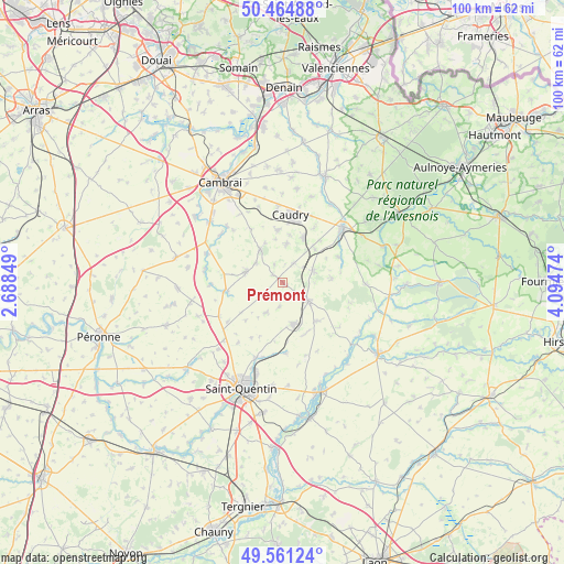
Prémont GPS coordinates[2]
50° 0' 54.648" North, 3° 23' 29.832" East
| Map corner | latitude | longitude |
|---|---|---|
| Upper-left | 50.46488°, | 2.68849° |
| Center: | 50.01518°, | 3.39162° |
| Lower-right: | 49.56124°, | 4.09474° |
| Map W x H: | 100.5×100.5 km | = 62.4×62.4mi |
| max Lat: | 51.07786° ⇑6.3% North |
| Prémont: | 50.01518° |
| min Lat: | ⇓93.7% South 41.3874° |
| min Long | Prémont | max Long |
| -5.08615° | 3.39162° | 9.52242° |
| W 63.1%⇐ | ⇒36.9% E |
Elevation
Elevation of Prémont is 158 m = 518 ft, and this is 35.7 m = 117 ft below average elevation for this country.
| Max E: |
2333 m = 7654 ft | 42.9% |
| Avg. | 193.7 m = 635 ft | |
| Prémont | 158 m = 518 ft | |
Min E: |
-1 m = -3 ft | 57.1% |
See also: France elevation on elevation.city.
Geographical zone
Prémont is located in North temperate zone (between Tropic of Cancer and the Arctic Circle). Distance of this North polar circle is 1840 km =1143.3 mi to North.| Distance of | km | miles | from Prémont |
|---|---|---|---|
| North Pole | 4445.9 | 2762.6 | to North |
| Arctic Circle | 1840 | 1143.3 | to North |
| Tropic Cancer | 2955.2 | 1836.3 | to South |
| Equator | 5561.2 | 3455.6 | to South |


Nearby cities:
15 places around Prémont: (largest is in red/bold)
• Beaurevoir
6.3 km =3.9 mi,  251°
251°
• Bertry
8.8 km =5.5 mi,  24°
24°
• Bohain-en-Vermandois
5.4 km =3.4 mi,  125°
125°
• Brancourt-le-Grand
4.4 km =2.7 mi,  189°
189°
• Busigny
5.8 km =3.6 mi,  68°
68°
• Clary
7 km =4.3 mi,  4°
4°
• Fresnoy-le-Grand
7.8 km =4.8 mi,  165°
165°
• Honnechy
8.3 km =5.2 mi,  43°
43°
• Maretz
3.8 km =2.4 mi,  29°
29°
• Montbrehain
6.2 km =3.9 mi,  209°
209°
• Montigny-en-Cambrésis
8.5 km =5.3 mi,  9°
9°
• Selvigny
7.8 km =4.8 mi,  337°
337°
• Villers-Outréaux
7 km =4.3 mi,  289°
289°
• Walincourt-Selvigny
7.1 km =4.4 mi,  323°
323°
• Élincourt
3.6 km =2.2 mi, 336°
Sources, notices
• [Note1] Compared only with cities in France existing in our database
• [Src1] Map data: © OpenStreetMap contributors (CC-BY-SA)
• [Src2] Other city data from geonames.org with taken over terms of usage.
• [Src3] Geographical zone / Annual Mean Temperature by Robert A. Rohde @ Wikipedia
