Fresnoy-le-Grand geodata
Fresnoy-le-Grand (Hauts-de-France) is a populated place; located in France in Europe/Paris (GMT+2) time zone. With population of 3,013 people, there are 3238 cities with bigger population in this country. Compared to other cities in France, 93.3% of cities are located further ↓South; 63.4% of cities are located further ←West and 55.2% of cities have higher elevation than Fresnoy-le-Grand. Note1
Administrative division(s):
- Level 1: Hauts-de-France
- Level 2: Département de l'Aisne
- Level 3: Arrondissement de Saint-Quentin
- Level 4: Fresnoy-le-Grand


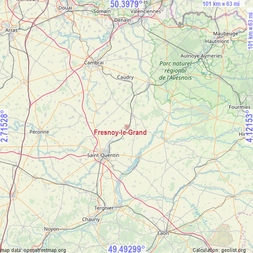
Fresnoy-le-Grand GPS coordinates[2]
49° 56' 51.252" North, 3° 25' 6.276" East
| Map corner | latitude | longitude |
|---|---|---|
| Upper-left | 50.3979°, | 2.71528° |
| Center: | 49.94757°, | 3.41841° |
| Lower-right: | 49.49299°, | 4.12153° |
| Map W x H: | 100.6×100.6 km | = 62.5×62.5mi |
| max Lat: | 51.07786° ⇑6.7% North |
| Fresnoy-le-Grand: | 49.94757° |
| min Lat: | ⇓93.3% South 41.3874° |
| min Long | Fresnoy-le-Gran | max Long |
| -5.08615° | 3.41841° | 9.52242° |
| W 63.4%⇐ | ⇒36.6% E |
Elevation
Elevation of Fresnoy-le-Grand is 116 m = 381 ft, and this is 77.7 m = 255 ft below average elevation for this country.
| Max E: |
2333 m = 7654 ft | 55.2% |
| Avg. | 193.7 m = 635 ft | |
| Fresnoy-le-Grand | 116 m = 381 ft | |
Min E: |
-1 m = -3 ft | 44.8% |
See also: France elevation on elevation.city.
Geographical zone
Fresnoy-le-Grand is located in North temperate zone (between Tropic of Cancer and the Arctic Circle). Distance of this North polar circle is 1847.5 km =1148 mi to North.| Distance of | km | miles | from Fresnoy-le-Grand |
|---|---|---|---|
| North Pole | 4453.4 | 2767.2 | to North |
| Arctic Circle | 1847.5 | 1148 | to North |
| Tropic Cancer | 2947.7 | 1831.6 | to South |
| Equator | 5553.6 | 3450.8 | to South |


Nearby cities:
15 places around Fresnoy-le-Grand: (largest is in red/bold)
• Beaurevoir
9.6 km =6 mi,  305°
305°
• Bohain-en-Vermandois
5.1 km =3.2 mi,  29°
29°
• Brancourt-le-Grand
4.1 km =2.5 mi,  320°
320°
• Busigny
10.2 km =6.3 mi,  19°
19°
• Fonsomme
5.5 km =3.4 mi,  193°
193°
• Lesdins
8.4 km =5.2 mi,  228°
228°
• Levergies
8 km =5 mi,  252°
252°
• Mennevret
10.7 km =6.6 mi,  66°
66°
• Montbrehain
5.4 km =3.4 mi,  293°
293°
• Morcourt
10.6 km =6.6 mi,  220°
220°
• Prémont
7.8 km =4.8 mi,  345°
345°
• Seboncourt
4.2 km =2.6 mi,  82°
82°
• Vadencourt
10.7 km =6.6 mi,  98°
98°
• Vaux-Andigny
10.9 km =6.8 mi,  40°
40°
• Étaves-et-Bocquiaux
2.9 km =1.8 mi,  108°
108°
Sources, notices
• [Note1] Compared only with cities in France existing in our database
• [Src1] Map data: © OpenStreetMap contributors (CC-BY-SA)
• [Src2] Other city data from geonames.org with taken over terms of usage.
• [Src3] Geographical zone / Annual Mean Temperature by Robert A. Rohde @ Wikipedia
