Montbrehain geodata
Montbrehain (Hauts-de-France) is a populated place; located in France in Europe/Paris (GMT+2) time zone. With population of 921 people, there are 9479 cities with bigger population in this country. Compared to other cities in France, 93.4% of cities are located further ↓South; 62.6% of cities are located further ←West and 53.3% of cities have lower elevation than Montbrehain. Note1
Administrative division(s):
- Level 1: Hauts-de-France
- Level 2: Département de l'Aisne
- Level 3: Arrondissement de Saint-Quentin
- Level 4: Montbrehain


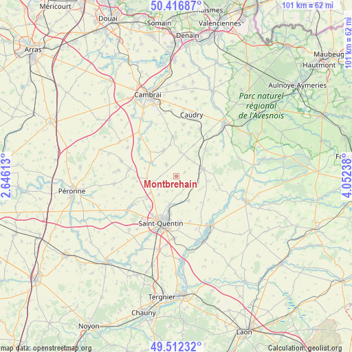
Montbrehain GPS coordinates[2]
49° 58' 0.192" North, 3° 20' 57.336" East
| Map corner | latitude | longitude |
|---|---|---|
| Upper-left | 50.41687°, | 2.64613° |
| Center: | 49.96672°, | 3.34926° |
| Lower-right: | 49.51232°, | 4.05238° |
| Map W x H: | 100.6×100.6 km | = 62.5×62.5mi |
| max Lat: | 51.07786° ⇑6.6% North |
| Montbrehain: | 49.96672° |
| min Lat: | ⇓93.4% South 41.3874° |
| min Long | Montbrehain | max Long |
| -5.08615° | 3.34926° | 9.52242° |
| W 62.6%⇐ | ⇒37.4% E |
Elevation
Elevation of Montbrehain is 144 m = 472 ft, and this is 49.7 m = 163 ft below average elevation for this country.
| Max E: |
2333 m = 7654 ft | 46.7% |
| Avg. | 193.7 m = 635 ft | |
| Montbrehain | 144 m = 472 ft | |
Min E: |
-1 m = -3 ft | 53.3% |
See also: France elevation on elevation.city.
Geographical zone
Montbrehain is located in North temperate zone (between Tropic of Cancer and the Arctic Circle). Distance of this North polar circle is 1845.4 km =1146.7 mi to North.| Distance of | km | miles | from Montbrehain |
|---|---|---|---|
| North Pole | 4451.3 | 2765.9 | to North |
| Arctic Circle | 1845.4 | 1146.7 | to North |
| Tropic Cancer | 2949.9 | 1833 | to South |
| Equator | 5555.8 | 3452.2 | to South |


Nearby cities:
15 places around Montbrehain: (largest is in red/bold)
• Beaurevoir
4.5 km =2.8 mi,  319°
319°
• Bellicourt
8.2 km =5.1 mi,  266°
266°
• Bohain-en-Vermandois
7.8 km =4.8 mi,  72°
72°
• Brancourt-le-Grand
2.6 km =1.6 mi, 65°
• Fonsomme
8.3 km =5.2 mi,  153°
153°
• Fresnoy-le-Grand
5.4 km =3.4 mi,  113°
113°
• Gouy
7.7 km =4.8 mi,  299°
299°
• Lesdins
7.8 km =4.8 mi,  189°
189°
• Levergies
5.2 km =3.2 mi,  210°
210°
• Nauroy
6.9 km =4.3 mi,  257°
257°
• Prémont
6.2 km =3.9 mi,  29°
29°
• Seboncourt
9.2 km =5.7 mi,  99°
99°
• Villers-Outréaux
8.5 km =5.3 mi,  335°
335°
• Élincourt
8.8 km =5.5 mi,  10°
10°
• Étaves-et-Bocquiaux
8.2 km =5.1 mi, 111°
Sources, notices
• [Note1] Compared only with cities in France existing in our database
• [Src1] Map data: © OpenStreetMap contributors (CC-BY-SA)
• [Src2] Other city data from geonames.org with taken over terms of usage.
• [Src3] Geographical zone / Annual Mean Temperature by Robert A. Rohde @ Wikipedia
