Pont-Saint-Pierre geodata
Pont-Saint-Pierre (Normandy) is a populated place; located in France in Europe/Paris (GMT+2) time zone. With population of 1,092 people, there are 8182 cities with bigger population in this country. Compared to other cities in France, 86.7% of cities are located further ↓South; 65.9% of cities are located further →East and 96% of cities have higher elevation than Pont-Saint-Pierre. Note1
Administrative division(s):
- Level 1: Normandy
- Level 2: Département de l'Eure
- Level 3: Les Andelys
- Level 4: Pont-Saint-Pierre


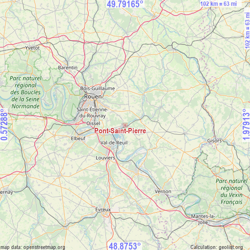
Pont-Saint-Pierre GPS coordinates[2]
49° 20' 8.196" North, 1° 16' 33.636" East
| Map corner | latitude | longitude |
|---|---|---|
| Upper-left | 49.79165°, | 0.57288° |
| Center: | 49.33561°, | 1.27601° |
| Lower-right: | 48.8753°, | 1.97913° |
| Map W x H: | 101.9×101.9 km | = 63.3×63.3mi |
| max Lat: | 51.07786° ⇑13.3% North |
| Pont-Saint-Pierre: | 49.33561° |
| min Lat: | ⇓86.7% South 41.3874° |
| min Long | Pont-Saint-Pier | max Long |
| -5.08615° | 1.27601° | 9.52242° |
| W 34.1%⇐ | ⇒65.9% E |
Elevation
Elevation of Pont-Saint-Pierre is 14 m = 46 ft, and this is 179.7 m = 590 ft below average elevation for this country.
| Max E: |
2333 m = 7654 ft | 96% |
| Avg. | 193.7 m = 635 ft | |
| Pont-Saint-Pierre | 14 m = 46 ft | |
Min E: |
-1 m = -3 ft | 4% |
See also: France elevation on elevation.city.
Geographical zone
Pont-Saint-Pierre is located in North temperate zone (between Tropic of Cancer and the Arctic Circle). Distance of this North polar circle is 1915.6 km =1190.3 mi to North.| Distance of | km | miles | from Pont-Saint-Pierre |
|---|---|---|---|
| North Pole | 4521.5 | 2809.5 | to North |
| Arctic Circle | 1915.6 | 1190.3 | to North |
| Tropic Cancer | 2879.7 | 1789.4 | to South |
| Equator | 5485.6 | 3408.6 | to South |


Nearby cities:
15 places around Pont-Saint-Pierre: (largest is in red/bold)
• Alizay
7.2 km =4.5 mi,  257°
257°
• Boos
7.9 km =4.9 mi,  318°
318°
• Bourg-Beaudouin
6.2 km =3.9 mi,  23°
23°
• Fleury-sur-Andelle
6.5 km =4 mi,  63°
63°
• Grainville
6.7 km =4.2 mi,  78°
78°
• Le Manoir
5.7 km =3.5 mi,  244°
244°
• Léry
7.4 km =4.6 mi,  221°
221°
• Mesnil-Raoul
6.8 km =4.2 mi,  359°
359°
• Poses
4.1 km =2.5 mi, 215°
• Pîtres
3.7 km =2.3 mi, 235°
• Quévreville-la-Poterie
6.6 km =4.1 mi,  289°
289°
• Radepont
4.2 km =2.6 mi,  65°
65°
• Romilly-sur-Andelle
1.1 km =0.7 mi,  248°
248°
• Vandrimare
6.9 km =4.3 mi,  45°
45°
• Ymare
7.2 km =4.5 mi,  283°
283°
Sources, notices
• [Note1] Compared only with cities in France existing in our database
• [Src1] Map data: © OpenStreetMap contributors (CC-BY-SA)
• [Src2] Other city data from geonames.org with taken over terms of usage.
• [Src3] Geographical zone / Annual Mean Temperature by Robert A. Rohde @ Wikipedia
