Pomas geodata
Pomas (Occitanie) is a populated place; located in France in Europe/Paris (GMT+2) time zone. With population of 703 people, there are 11764 cities with bigger population in this country. Compared to other cities in France, 97.9% of cities are located further ↑North; 52.9% of cities are located further →East and 59.1% of cities have lower elevation than Pomas. Note1
Administrative division(s):
- Level 1: Occitanie
- Level 2: Département de l'Aude
- Level 3: Arrondissement de Limoux
- Level 4: Pomas


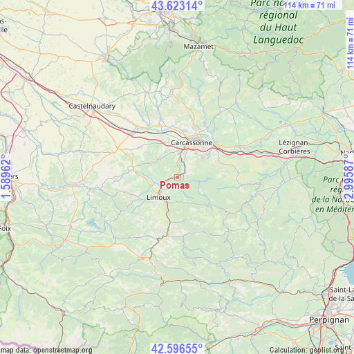
Pomas GPS coordinates[2]
43° 6' 43.2" North, 2° 17' 33.864" East
| Map corner | latitude | longitude |
|---|---|---|
| Upper-left | 43.62314°, | 1.58962° |
| Center: | 43.112°, | 2.29274° |
| Lower-right: | 42.59655°, | 2.99587° |
| Map W x H: | 114.1×114.1 km | = 70.9×70.9mi |
| max Lat: | 51.07786° ⇑97.9% North |
| Pomas: | 43.112° |
| min Lat: | ⇓2.1% South 41.3874° |
| min Long | Pomas | max Long |
| -5.08615° | 2.29274° | 9.52242° |
| W 47.1%⇐ | ⇒52.9% E |
Elevation
Elevation of Pomas is 166 m = 545 ft, and this is 27.7 m = 91 ft below average elevation for this country.
| Max E: |
2333 m = 7654 ft | 40.9% |
| Avg. | 193.7 m = 635 ft | |
| Pomas | 166 m = 545 ft | |
Min E: |
-1 m = -3 ft | 59.1% |
See also: France elevation on elevation.city.
Geographical zone
Pomas is located in North temperate zone (between Tropic of Cancer and the Arctic Circle). Distance of this Northern Tropic circle is 2187.7 km =1359.4 mi to South.| Distance of | km | miles | from Pomas |
|---|---|---|---|
| North Pole | 5213.5 | 3239.5 | to North |
| Arctic Circle | 2607.6 | 1620.3 | to North |
| Tropic Cancer | 2187.7 | 1359.4 | to South |
| Equator | 4793.6 | 2978.6 | to South |


Nearby cities:
15 places around Pomas: (largest is in red/bold)
• Alairac
9.1 km =5.7 mi,  332°
332°
• Arzens
11.7 km =7.3 mi,  324°
324°
• Carcassonne
12.3 km =7.6 mi,  22°
22°
• Caux-et-Sauzens
12.9 km =8 mi,  346°
346°
• Cavanac
6.8 km =4.2 mi, 24°
• Cazilhac
9.5 km =5.9 mi,  35°
35°
• Couffoulens
4.9 km =3 mi,  13°
13°
• Cournanel
10 km =6.2 mi,  208°
208°
• Cépie
3.9 km =2.4 mi,  258°
258°
• Lavalette
8.3 km =5.2 mi, 346°
• Leuc
4.6 km =2.9 mi,  32°
32°
• Limoux
8.6 km =5.3 mi,  222°
222°
• Palaja
10.1 km =6.3 mi,  47°
47°
• Pieusse
6.1 km =3.8 mi,  233°
233°
• Saint-Hilaire
2.6 km =1.6 mi,  146°
146°
Sources, notices
• [Note1] Compared only with cities in France existing in our database
• [Src1] Map data: © OpenStreetMap contributors (CC-BY-SA)
• [Src2] Other city data from geonames.org with taken over terms of usage.
• [Src3] Geographical zone / Annual Mean Temperature by Robert A. Rohde @ Wikipedia
