Plouray geodata
Plouray (Brittany) is a populated place; located in France in Europe/Paris (GMT+2) time zone. With population of 1,105 people, there are 8096 cities with bigger population in this country. Compared to other cities in France, 61.9% of cities are located further ↓South; 98.1% of cities are located further →East and 65% of cities have lower elevation than Plouray. Note1
Administrative division(s):
- Level 1: Brittany
- Level 2: Morbihan
- Level 3: Arrondissement de Pontivy
- Level 4: Plouray


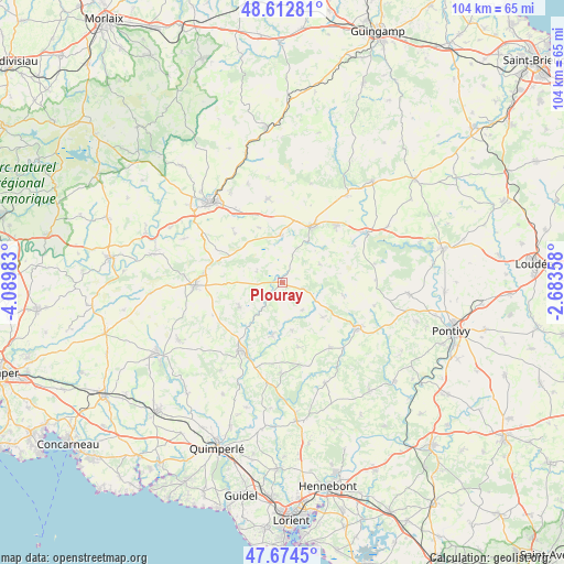
Plouray GPS coordinates[2]
48° 8' 44.88" North, 3° 23' 12.156" West
| Map corner | latitude | longitude |
|---|---|---|
| Upper-left | 48.61281°, | -4.08983° |
| Center: | 48.1458°, | -3.38671° |
| Lower-right: | 47.6745°, | -2.68358° |
| Map W x H: | 104.3×104.3 km | = 64.8×64.8mi |
| max Lat: | 51.07786° ⇑38.1% North |
| Plouray: | 48.1458° |
| min Lat: | ⇓61.9% South 41.3874° |
| min Long | Plouray | max Long |
| -5.08615° | -3.38671° | 9.52242° |
| W 1.9%⇐ | ⇒98.1% E |
Elevation
Elevation of Plouray is 194 m = 636 ft, and this is 0.30000000000001 m = 1 ft above average elevation for this country.
| Max E: |
2333 m = 7654 ft | 35% |
| Plouray | 194 m 636 ft | |
| Avg. | 193.7 m = 635 ft | |
Min E: |
-1 m = -3 ft | 65% |
See also: France elevation on elevation.city.
Geographical zone
Plouray is located in North temperate zone (between Tropic of Cancer and the Arctic Circle). Distance of this North polar circle is 2047.9 km =1272.5 mi to North.| Distance of | km | miles | from Plouray |
|---|---|---|---|
| North Pole | 4653.8 | 2891.7 | to North |
| Arctic Circle | 2047.9 | 1272.5 | to North |
| Tropic Cancer | 2747.4 | 1707.2 | to South |
| Equator | 5353.3 | 3326.4 | to South |


Nearby cities:
15 places around Plouray: (largest is in red/bold)
• Glomel
8.6 km =5.3 mi,  354°
354°
• Langonnet
9.1 km =5.7 mi,  240°
240°
• Le Croisty
9.2 km =5.7 mi,  169°
169°
• Le Faouët
14.7 km =9.1 mi,  211°
211°
• Le Saint
14.4 km =8.9 mi, 244°
• Lignol
14.9 km =9.3 mi,  144°
144°
• Maël-Carhaix
15.7 km =9.8 mi, 350°
• Motreff
13.9 km =8.6 mi,  296°
296°
• Paule
10.8 km =6.7 mi,  337°
337°
• Plouguernével
14.5 km =9 mi,  44°
44°
• Ploërdut
9.9 km =6.2 mi,  130°
130°
• Plélauff
14.9 km =9.3 mi,  63°
63°
• Plévin
11.5 km =7.1 mi,  313°
313°
• Priziac
9.1 km =5.7 mi,  194°
194°
• Rostrenen
11.5 km =7.1 mi,  27°
27°
Sources, notices
• [Note1] Compared only with cities in France existing in our database
• [Src1] Map data: © OpenStreetMap contributors (CC-BY-SA)
• [Src2] Other city data from geonames.org with taken over terms of usage.
• [Src3] Geographical zone / Annual Mean Temperature by Robert A. Rohde @ Wikipedia
