Plestan geodata
Plestan (Brittany) is a populated place; located in France in Europe/Paris (GMT+2) time zone. With population of 1,447 people, there are 6401 cities with bigger population in this country. Compared to other cities in France, 66.8% of cities are located further ↓South; 96.1% of cities are located further →East and 62.4% of cities have higher elevation than Plestan. Note1
Administrative division(s):
- Level 1: Brittany
- Level 2: Département des Côtes-d’Armor
- Level 3: Arrondissement de Saint-Brieuc
- Level 4: Plestan


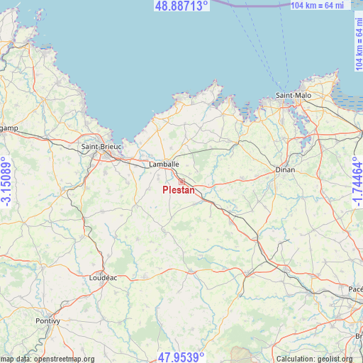
Plestan GPS coordinates[2]
48° 25' 21.576" North, 2° 26' 51.972" West
| Map corner | latitude | longitude |
|---|---|---|
| Upper-left | 48.88713°, | -3.15089° |
| Center: | 48.42266°, | -2.44777° |
| Lower-right: | 47.9539°, | -1.74464° |
| Map W x H: | 103.8×103.8 km | = 64.5×64.5mi |
| max Lat: | 51.07786° ⇑33.2% North |
| Plestan: | 48.42266° |
| min Lat: | ⇓66.8% South 41.3874° |
| min Long | Plestan | max Long |
| -5.08615° | -2.44777° | 9.52242° |
| W 3.9%⇐ | ⇒96.1% E |
Elevation
Elevation of Plestan is 96 m = 315 ft, and this is 97.7 m = 321 ft below average elevation for this country.
| Max E: |
2333 m = 7654 ft | 62.4% |
| Avg. | 193.7 m = 635 ft | |
| Plestan | 96 m = 315 ft | |
Min E: |
-1 m = -3 ft | 37.6% |
See also: France elevation on elevation.city.
Geographical zone
Plestan is located in North temperate zone (between Tropic of Cancer and the Arctic Circle). Distance of this North polar circle is 2017.1 km =1253.4 mi to North.| Distance of | km | miles | from Plestan |
|---|---|---|---|
| North Pole | 4623 | 2872.6 | to North |
| Arctic Circle | 2017.1 | 1253.4 | to North |
| Tropic Cancer | 2778.2 | 1726.3 | to South |
| Equator | 5384.1 | 3345.5 | to South |


Nearby cities:
15 places around Plestan: (largest is in red/bold)
• Andel
11.5 km =7.1 mi,  310°
310°
• Bréhand
9.6 km =6 mi,  257°
257°
• Jugon-les-Lacs
8.5 km =5.3 mi,  94°
94°
• Lamballe
7 km =4.3 mi,  315°
315°
• Landéhen
6.9 km =4.3 mi,  277°
277°
• Le Gouray
11 km =6.8 mi,  195°
195°
• Meslin
9.3 km =5.8 mi,  285°
285°
• Noyal
3.9 km =2.4 mi, 313°
• Plédéliac
5.6 km =3.5 mi,  57°
57°
• Plénée-Jugon
7.3 km =4.5 mi,  151°
151°
• Pléven
12.1 km =7.5 mi,  52°
52°
• Saint-Glen
9.1 km =5.7 mi,  218°
218°
• Sévignac
12.8 km =8 mi,  141°
141°
• Tramain
4.2 km =2.6 mi,  125°
125°
• Trébry
10.7 km =6.6 mi,  225°
225°
Sources, notices
• [Note1] Compared only with cities in France existing in our database
• [Src1] Map data: © OpenStreetMap contributors (CC-BY-SA)
• [Src2] Other city data from geonames.org with taken over terms of usage.
• [Src3] Geographical zone / Annual Mean Temperature by Robert A. Rohde @ Wikipedia
