Briarres-sur-Essonne geodata
Briarres-sur-Essonne (Centre) is a populated place; located in France in Europe/Paris (GMT+2) time zone. With population of 565 people, there are 13917 cities with bigger population in this country. Compared to other cities in France, 63.3% of cities are located further ↓South; 50.8% of cities are located further →East and 58.3% of cities have higher elevation than Briarres-sur-Essonne. Note1
Administrative division(s):
- Level 1: Centre
- Level 2: Loiret
- Level 3: Arrondissement de Pithiviers
- Level 4: Briarres-sur-Essonne


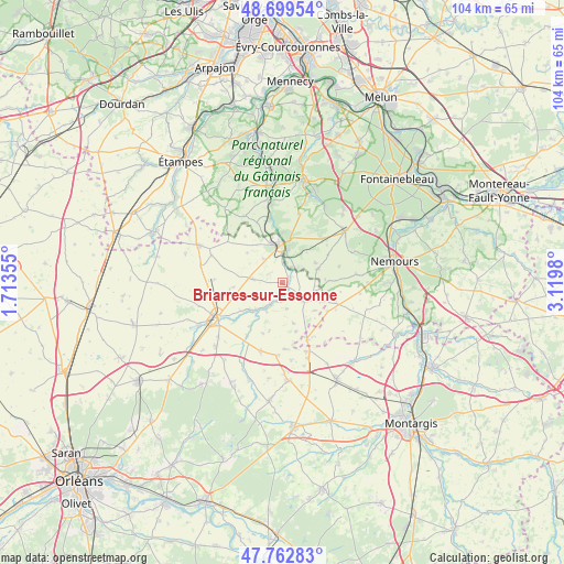
Briarres-sur-Essonne GPS coordinates[2]
48° 13' 59.988" North, 2° 25' 0.012" East
| Map corner | latitude | longitude |
|---|---|---|
| Upper-left | 48.69954°, | 1.71355° |
| Center: | 48.23333°, | 2.41667° |
| Lower-right: | 47.76283°, | 3.1198° |
| Map W x H: | 104.2×104.1 km | = 64.7×64.7mi |
| max Lat: | 51.07786° ⇑36.7% North |
| Briarres-sur-Essonne: | 48.23333° |
| min Lat: | ⇓63.3% South 41.3874° |
| min Long | Briarres-sur-Es | max Long |
| -5.08615° | 2.41667° | 9.52242° |
| W 49.2%⇐ | ⇒50.8% E |
Elevation
Elevation of Briarres-sur-Essonne is 107 m = 351 ft, and this is 86.7 m = 284 ft below average elevation for this country.
| Max E: |
2333 m = 7654 ft | 58.3% |
| Avg. | 193.7 m = 635 ft | |
| Briarres-sur-Essonne | 107 m = 351 ft | |
Min E: |
-1 m = -3 ft | 41.7% |
See also: France elevation on elevation.city.
Geographical zone
Briarres-sur-Essonne is located in North temperate zone (between Tropic of Cancer and the Arctic Circle). Distance of this North polar circle is 2038.1 km =1266.4 mi to North.| Distance of | km | miles | from Briarres-sur-Essonne |
|---|---|---|---|
| North Pole | 4644 | 2885.6 | to North |
| Arctic Circle | 2038.1 | 1266.4 | to North |
| Tropic Cancer | 2757.1 | 1713.2 | to South |
| Equator | 5363 | 3332.4 | to South |


Nearby cities:
15 places around Briarres-sur-Essonne: (largest is in red/bold)
• Aulnay-la-Rivière
6 km =3.7 mi,  217°
217°
• Auxy
13.5 km =8.4 mi,  161°
161°
• Beaumont-du-Gâtinais
11.5 km =7.1 mi, 156°
• Boynes
13.5 km =8.4 mi,  198°
198°
• Buno-Bonnevaux
13.8 km =8.6 mi,  350°
350°
• Buthiers
6.1 km =3.8 mi,  10°
10°
• Dadonville
13.7 km =8.5 mi,  232°
232°
• Estouy
8.2 km =5.1 mi, 231°
• Gironville-sur-Essonne
15 km =9.3 mi, 350°
• La Chapelle-la-Reine
14.8 km =9.2 mi,  50°
50°
• Larchant
14.3 km =8.9 mi,  66°
66°
• Malesherbes
7 km =4.3 mi,  355°
355°
• Manchecourt
5.5 km =3.4 mi,  275°
275°
• Pithiviers
14 km =8.7 mi,  240°
240°
• Yèvre-la-Ville
11.9 km =7.4 mi,  214°
214°
Sources, notices
• [Note1] Compared only with cities in France existing in our database
• [Src1] Map data: © OpenStreetMap contributors (CC-BY-SA)
• [Src2] Other city data from geonames.org with taken over terms of usage.
• [Src3] Geographical zone / Annual Mean Temperature by Robert A. Rohde @ Wikipedia
