Saint-Marcel-d'Ardèche geodata
Saint-Marcel-d'Ardèche (Auvergne-Rhône-Alpes) is a populated place; located in France in Europe/Paris (GMT+2) time zone. With population of 2,393 people, there are 4046 cities with bigger population in this country. Compared to other cities in France, 84.7% of cities are located further ↑North; 72.9% of cities are located further ←West and 51.4% of cities have lower elevation than Saint-Marcel-d'Ardèche. Note1
Administrative division(s):
- Level 1: Auvergne-Rhône-Alpes
- Level 2: Département de l'Ardèche
- Level 3: Arrondissement de Privas
- Level 4: Saint-Marcel-d'Ardèche
Current local time in Saint-Marcel-d'Ardèche:
07:38 PM, SaturdayDifference from your time zone: hours


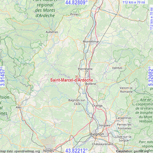
Saint-Marcel-d'Ardèche GPS coordinates[2]
44° 19' 38.136" North, 4° 37' 3.684" East
| Map corner | latitude | longitude |
|---|---|---|
| Upper-left | 44.82809°, | 3.91457° |
| Center: | 44.32726°, | 4.61769° |
| Lower-right: | 43.82212°, | 5.32082° |
| Map W x H: | 111.9×111.9 km | = 69.5×69.5mi |
| max Lat: | 51.07786° ⇑84.7% North |
| Saint-Marcel-d'Ardèche: | 44.32726° |
| min Lat: | ⇓15.3% South 41.3874° |
| min Long | Saint-Marcel-d' | max Long |
| -5.08615° | 4.61769° | 9.52242° |
| W 72.9%⇐ | ⇒27.1% E |
Elevation
Elevation of Saint-Marcel-d'Ardèche is 137 m = 449 ft, and this is 56.7 m = 186 ft below average elevation for this country.
| Max E: |
2333 m = 7654 ft | 48.6% |
| Avg. | 193.7 m = 635 ft | |
| Saint-Marcel-d'Ardèche | 137 m = 449 ft | |
Min E: |
-1 m = -3 ft | 51.4% |
See also: France elevation on elevation.city.
Geographical zone
Saint-Marcel-d'Ardèche is located in North temperate zone (between Tropic of Cancer and the Arctic Circle). Distance of this Northern Tropic circle is 2322.8 km =1443.3 mi to South.| Distance of | km | miles | from Saint-Marcel-d'Ardèche |
|---|---|---|---|
| North Pole | 5078.3 | 3155.5 | to North |
| Arctic Circle | 2472.4 | 1536.3 | to North |
| Tropic Cancer | 2322.8 | 1443.3 | to South |
| Equator | 4928.7 | 3062.6 | to South |


Nearby cities:
15 places around Saint-Marcel-d'Ardèche: (largest is in red/bold)
• Bollène
11.6 km =7.2 mi,  116°
116°
• Bourg-Saint-Andéol
5.5 km =3.4 mi,  22°
22°
• Carsan
10.5 km =6.5 mi,  189°
189°
• La Garde-Adhémar
13.6 km =8.5 mi,  55°
55°
• Lapalud
6.1 km =3.8 mi,  110°
110°
• Mondragon
12.5 km =7.8 mi,  142°
142°
• Pierrelatte
8.7 km =5.4 mi,  51°
51°
• Pont-Saint-Esprit
8.4 km =5.2 mi,  163°
163°
• Saint-Alexandre
11.1 km =6.9 mi,  178°
178°
• Saint-Julien-de-Peyrolas
6 km =3.7 mi,  224°
224°
• Saint-Just-d'Ardèche
3 km =1.9 mi, 181°
• Saint-Paul-Trois-Châteaux
11.8 km =7.3 mi,  79°
79°
• Saint-Paulet-de-Caisson
7.6 km =4.7 mi, 192°
• Saint-Remèze
11.7 km =7.3 mi,  308°
308°
• Saint-Restitut
13.9 km =8.6 mi,  91°
91°
Sources, notices
• [Note1] Compared only with cities in France existing in our database
• [Src1] Map data: © OpenStreetMap contributors (CC-BY-SA)
• [Src2] Other city data from geonames.org with taken over terms of usage.
• [Src3] Geographical zone / Annual Mean Temperature by Robert A. Rohde @ Wikipedia
