Bollène geodata
Bollène (Provence-Alpes-Côte d'Azur) is a populated place; located in France in Europe/Paris (GMT+2) time zone. With population of 14,703 people, there are 650 cities with bigger population in this country. Compared to other cities in France, 85% of cities are located further ↑North; 74.3% of cities are located further ←West and 76.2% of cities have higher elevation than Bollène. Note1
Administrative division(s):
- Level 1: Provence-Alpes-Côte d'Azur
- Level 2: Département du Vaucluse
- Level 3: Arrondissement de Carpentras
- Level 4: Bollène


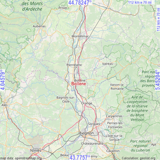
Bollène GPS coordinates[2]
44° 16' 52.464" North, 4° 44' 56.076" East
| Map corner | latitude | longitude |
|---|---|---|
| Upper-left | 44.78247°, | 4.04579° |
| Center: | 44.28124°, | 4.74891° |
| Lower-right: | 43.7757°, | 5.45204° |
| Map W x H: | 111.9×111.9 km | = 69.5×69.5mi |
| max Lat: | 51.07786° ⇑85% North |
| Bollène: | 44.28124° |
| min Lat: | ⇓15% South 41.3874° |
| min Long | Bollène | max Long |
| -5.08615° | 4.74891° | 9.52242° |
| W 74.3%⇐ | ⇒25.7% E |
Elevation
Elevation of Bollène is 64 m = 210 ft, and this is 129.7 m = 426 ft below average elevation for this country.
| Max E: |
2333 m = 7654 ft | 76.2% |
| Avg. | 193.7 m = 635 ft | |
| Bollène | 64 m = 210 ft | |
Min E: |
-1 m = -3 ft | 23.8% |
See also: France elevation on elevation.city.
Geographical zone
Bollène is located in North temperate zone (between Tropic of Cancer and the Arctic Circle). Distance of this Northern Tropic circle is 2317.7 km =1440.2 mi to South.| Distance of | km | miles | from Bollène |
|---|---|---|---|
| North Pole | 5083.4 | 3158.7 | to North |
| Arctic Circle | 2477.6 | 1539.5 | to North |
| Tropic Cancer | 2317.7 | 1440.2 | to South |
| Equator | 4923.6 | 3059.4 | to South |


Nearby cities:
15 places around Bollène: (largest is in red/bold)
• Bouchet
10.2 km =6.3 mi,  78°
78°
• La Baume-de-Transit
11.2 km =7 mi,  56°
56°
• Lapalud
5.6 km =3.5 mi,  301°
301°
• Mondragon
5.6 km =3.5 mi,  211°
211°
• Mornas
8.9 km =5.5 mi,  190°
190°
• Pierrelatte
11.1 km =6.9 mi,  340°
340°
• Pont-Saint-Esprit
8.6 km =5.3 mi,  250°
250°
• Rochegude
7.5 km =4.7 mi,  123°
123°
• Saint-Just-d'Ardèche
10.7 km =6.6 mi,  281°
281°
• Saint-Paul-Trois-Châteaux
7.3 km =4.5 mi,  9°
9°
• Saint-Restitut
5.9 km =3.7 mi,  36°
36°
• Saint-Étienne-des-Sorts
11.2 km =7 mi,  197°
197°
• Sainte-Cécile-les-Vignes
11.6 km =7.2 mi,  110°
110°
• Suze-la-Rousse
7.4 km =4.6 mi, 84°
• Uchaux
8.3 km =5.2 mi,  150°
150°
Sources, notices
• [Note1] Compared only with cities in France existing in our database
• [Src1] Map data: © OpenStreetMap contributors (CC-BY-SA)
• [Src2] Other city data from geonames.org with taken over terms of usage.
• [Src3] Geographical zone / Annual Mean Temperature by Robert A. Rohde @ Wikipedia
