Petit-Mars geodata
Petit-Mars (Pays de la Loire) is a populated place; located in France in Europe/Paris (GMT+2) time zone. With population of 2,629 people, there are 3706 cities with bigger population in this country. Compared to other cities in France, 50.2% of cities are located further ↑North; 91.9% of cities are located further →East and 91.6% of cities have higher elevation than Petit-Mars. Note1
Administrative division(s):
- Level 1: Pays de la Loire
- Level 2: Loire-Atlantique
- Level 3: Arrondissement of Châteaubriant-Ancenis
- Level 4: Petit-Mars


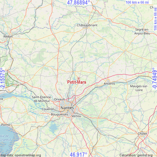
Petit-Mars GPS coordinates[2]
47° 23' 42.432" North, 1° 27' 9.432" West
| Map corner | latitude | longitude |
|---|---|---|
| Upper-left | 47.86894°, | -2.15575° |
| Center: | 47.39512°, | -1.45262° |
| Lower-right: | 46.917°, | -0.74949° |
| Map W x H: | 105.8×105.8 km | = 65.7×65.7mi |
| max Lat: | 51.07786° ⇑50.2% North |
| Petit-Mars: | 47.39512° |
| min Lat: | ⇓49.8% South 41.3874° |
| min Long | Petit-Mars | max Long |
| -5.08615° | -1.45262° | 9.52242° |
| W 8.1%⇐ | ⇒91.9% E |
Elevation
Elevation of Petit-Mars is 26 m = 85 ft, and this is 167.7 m = 550 ft below average elevation for this country.
| Max E: |
2333 m = 7654 ft | 91.6% |
| Avg. | 193.7 m = 635 ft | |
| Petit-Mars | 26 m = 85 ft | |
Min E: |
-1 m = -3 ft | 8.4% |
See also: France elevation on elevation.city.
Geographical zone
Petit-Mars is located in North temperate zone (between Tropic of Cancer and the Arctic Circle). Distance of this North polar circle is 2131.3 km =1324.3 mi to North.| Distance of | km | miles | from Petit-Mars |
|---|---|---|---|
| North Pole | 4737.2 | 2943.6 | to North |
| Arctic Circle | 2131.3 | 1324.3 | to North |
| Tropic Cancer | 2663.9 | 1655.3 | to South |
| Equator | 5269.8 | 3274.5 | to South |


Nearby cities:
15 places around Petit-Mars: (largest is in red/bold)
• Bourg de Joué-sur-Erdre
11.5 km =7.1 mi,  12°
12°
• Carquefou
11.1 km =6.9 mi,  194°
194°
• Casson
7.9 km =4.9 mi,  263°
263°
• Couffé
12 km =7.5 mi,  92°
92°
• La Chapelle-sur-Erdre
13.4 km =8.3 mi,  214°
214°
• Le Cellier
11.6 km =7.2 mi,  136°
136°
• Les Touches
5.5 km =3.4 mi,  17°
17°
• Ligné
5.9 km =3.7 mi,  72°
72°
• Mauves-sur-Loire
11.9 km =7.4 mi,  155°
155°
• Mouzeil
9.8 km =6.1 mi,  53°
53°
• Nort-sur-Erdre
6 km =3.7 mi,  324°
324°
• Oudon
13.7 km =8.5 mi,  112°
112°
• Saint-Mars-du-Désert
4.8 km =3 mi,  133°
133°
• Sucé-sur-Erdre
9.2 km =5.7 mi,  221°
221°
• Trans-sur-Erdre
10.8 km =6.7 mi,  33°
33°
Sources, notices
• [Note1] Compared only with cities in France existing in our database
• [Src1] Map data: © OpenStreetMap contributors (CC-BY-SA)
• [Src2] Other city data from geonames.org with taken over terms of usage.
• [Src3] Geographical zone / Annual Mean Temperature by Robert A. Rohde @ Wikipedia
