Marnay geodata
Marnay (Nouvelle-Aquitaine) is a populated place; located in France in Europe/Paris (GMT+2) time zone. With population of 568 people, there are 13863 cities with bigger population in this country. Compared to other cities in France, 61.1% of cities are located further ↑North; 74.9% of cities are located further →East and 51.7% of cities have higher elevation than Marnay. Note1
Administrative division(s):
- Level 1: Nouvelle-Aquitaine
- Level 2: Vienne
- Level 3: Arrondissement de Poitiers
- Level 4: Marnay


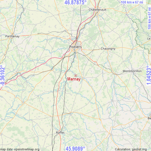
Marnay GPS coordinates[2]
46° 23' 45.528" North, 0° 20' 31.56" East
| Map corner | latitude | longitude |
|---|---|---|
| Upper-left | 46.87875°, | -0.36102° |
| Center: | 46.39598°, | 0.3421° |
| Lower-right: | 45.9089°, | 1.04523° |
| Map W x H: | 107.8×107.8 km | = 67×67mi |
| max Lat: | 51.07786° ⇑61.1% North |
| Marnay: | 46.39598° |
| min Lat: | ⇓38.9% South 41.3874° |
| min Long | Marnay | max Long |
| -5.08615° | 0.3421° | 9.52242° |
| W 25.1%⇐ | ⇒74.9% E |
Elevation
Elevation of Marnay is 126 m = 413 ft, and this is 67.7 m = 222 ft below average elevation for this country.
| Max E: |
2333 m = 7654 ft | 51.7% |
| Avg. | 193.7 m = 635 ft | |
| Marnay | 126 m = 413 ft | |
Min E: |
-1 m = -3 ft | 48.3% |
See also: France elevation on elevation.city.
Geographical zone
Marnay is located in North temperate zone (between Tropic of Cancer and the Arctic Circle). Distance of this North polar circle is 2242.4 km =1393.4 mi to North.| Distance of | km | miles | from Marnay |
|---|---|---|---|
| North Pole | 4848.3 | 3012.6 | to North |
| Arctic Circle | 2242.4 | 1393.4 | to North |
| Tropic Cancer | 2552.8 | 1586.2 | to South |
| Equator | 5158.7 | 3205.5 | to South |


Nearby cities:
15 places around Marnay: (largest is in red/bold)
• Aslonnes
0.8 km =0.5 mi,  303°
303°
• Ceaux-en-Couhé
12.1 km =7.5 mi,  223°
223°
• Celle-Lévescault
12.3 km =7.6 mi,  284°
284°
• Champagné-Saint-Hilaire
8.6 km =5.3 mi,  188°
188°
• Château-Larcher
3.2 km =2 mi,  317°
317°
• Iteuil
10.6 km =6.6 mi,  347°
347°
• La Villedieu-du-Clain
6.9 km =4.3 mi,  17°
17°
• Magné
5.9 km =3.7 mi,  138°
138°
• Marçay
11.5 km =7.1 mi,  310°
310°
• Payré
11.8 km =7.3 mi,  238°
238°
• Roches-Prémarie-Andillé
10.1 km =6.3 mi,  12°
12°
• Saint-Maurice-la-Clouère
5.7 km =3.5 mi,  108°
108°
• Smarves
12.8 km =8 mi,  2°
2°
• Vernon
11.4 km =7.1 mi,  64°
64°
• Vivonne
7.1 km =4.4 mi, 302°
Sources, notices
• [Note1] Compared only with cities in France existing in our database
• [Src1] Map data: © OpenStreetMap contributors (CC-BY-SA)
• [Src2] Other city data from geonames.org with taken over terms of usage.
• [Src3] Geographical zone / Annual Mean Temperature by Robert A. Rohde @ Wikipedia
