Pas-en-Artois geodata
Pas-en-Artois (Hauts-de-France) is a populated place; located in France in Europe/Paris (GMT+2) time zone. With population of 963 people, there are 9104 cities with bigger population in this country. Compared to other cities in France, 94.6% of cities are located further ↓South; 50.4% of cities are located further ←West and 64% of cities have higher elevation than Pas-en-Artois. Note1
Administrative division(s):
- Level 1: Hauts-de-France
- Level 2: Pas-de-Calais
- Level 3: Arras
- Level 4: Pas-en-Artois


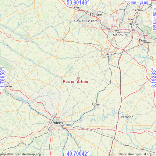
Pas-en-Artois GPS coordinates[2]
50° 9' 11.016" North, 2° 29' 22.92" East
| Map corner | latitude | longitude |
|---|---|---|
| Upper-left | 50.60146°, | 1.78658° |
| Center: | 50.15306°, | 2.4897° |
| Lower-right: | 49.70042°, | 3.19283° |
| Map W x H: | 100.2×100.2 km | = 62.3×62.3mi |
| max Lat: | 51.07786° ⇑5.4% North |
| Pas-en-Artois: | 50.15306° |
| min Lat: | ⇓94.6% South 41.3874° |
| min Long | Pas-en-Artois | max Long |
| -5.08615° | 2.4897° | 9.52242° |
| W 50.4%⇐ | ⇒49.6% E |
Elevation
Elevation of Pas-en-Artois is 92 m = 302 ft, and this is 101.7 m = 334 ft below average elevation for this country.
| Max E: |
2333 m = 7654 ft | 64% |
| Avg. | 193.7 m = 635 ft | |
| Pas-en-Artois | 92 m = 302 ft | |
Min E: |
-1 m = -3 ft | 36% |
See also: France elevation on elevation.city.
Geographical zone
Pas-en-Artois is located in North temperate zone (between Tropic of Cancer and the Arctic Circle). Distance of this North polar circle is 1824.7 km =1133.8 mi to North.| Distance of | km | miles | from Pas-en-Artois |
|---|---|---|---|
| North Pole | 4430.6 | 2753 | to North |
| Arctic Circle | 1824.7 | 1133.8 | to North |
| Tropic Cancer | 2970.6 | 1845.8 | to South |
| Equator | 5576.5 | 3465.1 | to South |


Nearby cities:
15 places around Pas-en-Artois: (largest is in red/bold)
• Acheux-en-Amiénois
9.4 km =5.8 mi,  161°
161°
• Avesnes-le-Comte
14.1 km =8.8 mi,  11°
11°
• Beaumetz-lès-Loges
15.3 km =9.5 mi,  51°
51°
• Beauquesne
10.2 km =6.3 mi,  222°
222°
• Beauval
12.3 km =7.6 mi,  245°
245°
• Bucquoy
15.8 km =9.8 mi,  95°
95°
• Doullens
10.7 km =6.6 mi,  272°
272°
• Hérissart
15 km =9.3 mi,  200°
200°
• Lucheux
7.3 km =4.5 mi,  311°
311°
• Mailly-Maillet
11.5 km =7.1 mi,  134°
134°
• Mondicourt
2.9 km =1.8 mi,  316°
316°
• Puisieux
15.1 km =9.4 mi,  105°
105°
• Simencourt
16 km =9.9 mi,  43°
43°
• Wanquetin
16.3 km =10.1 mi,  32°
32°
• Warloy-Baillon
16.1 km =10 mi,  171°
171°
Sources, notices
• [Note1] Compared only with cities in France existing in our database
• [Src1] Map data: © OpenStreetMap contributors (CC-BY-SA)
• [Src2] Other city data from geonames.org with taken over terms of usage.
• [Src3] Geographical zone / Annual Mean Temperature by Robert A. Rohde @ Wikipedia
