Doullens geodata
Doullens (Hauts-de-France) is a populated place; located in France in Europe/Paris (GMT+2) time zone. With population of 6,295 people, there are 1577 cities with bigger population in this country. Compared to other cities in France, 94.6% of cities are located further ↓South; 52% of cities are located further →East and 77.8% of cities have higher elevation than Doullens. Note1
Administrative division(s):
- Level 1: Hauts-de-France
- Level 2: Somme
- Level 3: Amiens
- Level 4: Doullens


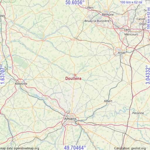
Doullens GPS coordinates[2]
50° 9' 26.064" North, 2° 20' 24.684" East
| Map corner | latitude | longitude |
|---|---|---|
| Upper-left | 50.6056°, | 1.63707° |
| Center: | 50.15724°, | 2.34019° |
| Lower-right: | 49.70464°, | 3.04332° |
| Map W x H: | 100.2×100.2 km | = 62.3×62.3mi |
| max Lat: | 51.07786° ⇑5.4% North |
| Doullens: | 50.15724° |
| min Lat: | ⇓94.6% South 41.3874° |
| min Long | Doullens | max Long |
| -5.08615° | 2.34019° | 9.52242° |
| W 48%⇐ | ⇒52% E |
Elevation
Elevation of Doullens is 60 m = 197 ft, and this is 133.7 m = 439 ft below average elevation for this country.
| Max E: |
2333 m = 7654 ft | 77.8% |
| Avg. | 193.7 m = 635 ft | |
| Doullens | 60 m = 197 ft | |
Min E: |
-1 m = -3 ft | 22.2% |
See also: France elevation on elevation.city.
Geographical zone
Doullens is located in North temperate zone (between Tropic of Cancer and the Arctic Circle). Distance of this North polar circle is 1824.2 km =1133.5 mi to North.| Distance of | km | miles | from Doullens |
|---|---|---|---|
| North Pole | 4430.1 | 2752.7 | to North |
| Arctic Circle | 1824.2 | 1133.5 | to North |
| Tropic Cancer | 2971 | 1846.1 | to South |
| Equator | 5577 | 3465.4 | to South |


Nearby cities:
15 places around Doullens: (largest is in red/bold)
• Beauquesne
8.8 km =5.5 mi,  154°
154°
• Beauval
5.5 km =3.4 mi,  185°
185°
• Bernaville
12.9 km =8 mi,  257°
257°
• Bonnières
11.1 km =6.9 mi,  329°
329°
• Canaples
14.2 km =8.8 mi,  217°
217°
• Candas
8 km =5 mi,  225°
225°
• Fienvillers
9 km =5.6 mi,  241°
241°
• Frévent
13.7 km =8.5 mi,  344°
344°
• Hérissart
15.5 km =9.6 mi,  159°
159°
• Lucheux
6.8 km =4.2 mi,  49°
49°
• Mondicourt
8.8 km =5.5 mi,  79°
79°
• Naours
14.1 km =8.8 mi,  198°
198°
• Pas-en-Artois
10.7 km =6.6 mi,  92°
92°
• Rubempré
15.8 km =9.8 mi,  168°
168°
• Talmas
14.1 km =8.8 mi,  184°
184°
Sources, notices
• [Note1] Compared only with cities in France existing in our database
• [Src1] Map data: © OpenStreetMap contributors (CC-BY-SA)
• [Src2] Other city data from geonames.org with taken over terms of usage.
• [Src3] Geographical zone / Annual Mean Temperature by Robert A. Rohde @ Wikipedia
