Orbey geodata
Orbey (Grand Est) is a populated place; located in France in Europe/Paris (GMT+2) time zone. With population of 3,729 people, there are 2637 cities with bigger population in this country. Compared to other cities in France, 61.6% of cities are located further ↓South; 95.6% of cities are located further ←West and 91.9% of cities have lower elevation than Orbey. Note1
Administrative division(s):
- Level 1: Grand Est
- Level 2: Haut-Rhin
- Level 3: Arrondissement de Colmar-Ribeauvillé
- Level 4: Orbey


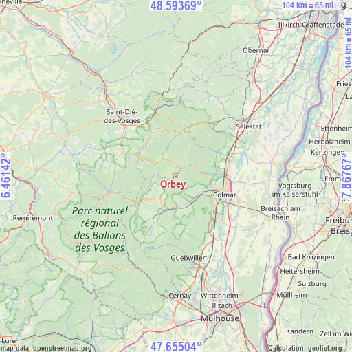
Orbey GPS coordinates[2]
48° 7' 35.436" North, 7° 9' 52.38" East
| Map corner | latitude | longitude |
|---|---|---|
| Upper-left | 48.59369°, | 6.46142° |
| Center: | 48.12651°, | 7.16455° |
| Lower-right: | 47.65504°, | 7.86767° |
| Map W x H: | 104.4×104.4 km | = 64.9×64.9mi |
| max Lat: | 51.07786° ⇑38.4% North |
| Orbey: | 48.12651° |
| min Lat: | ⇓61.6% South 41.3874° |
| min Long | Orbey | max Long |
| -5.08615° | 7.16455° | 9.52242° |
| W 95.6%⇐ | ⇒4.4% E |
Elevation
Elevation of Orbey is 473 m = 1552 ft, and this is 279.3 m = 916 ft above average elevation for this country.
| Max E: |
2333 m = 7654 ft | 8.1% |
| Orbey | 473 m 1552 ft | |
| Avg. | 193.7 m = 635 ft | |
Min E: |
-1 m = -3 ft | 91.9% |
See also: France elevation on elevation.city.
Geographical zone
Orbey is located in North temperate zone (between Tropic of Cancer and the Arctic Circle). Distance of this North polar circle is 2050 km =1273.8 mi to North.| Distance of | km | miles | from Orbey |
|---|---|---|---|
| North Pole | 4655.9 | 2893 | to North |
| Arctic Circle | 2050 | 1273.8 | to North |
| Tropic Cancer | 2745.2 | 1705.8 | to South |
| Equator | 5351.2 | 3325.1 | to South |


Nearby cities:
15 places around Orbey: (largest is in red/bold)
• Ammerschwihr
8.8 km =5.5 mi,  90°
90°
• Fréland
5.5 km =3.4 mi,  21°
21°
• Gunsbach
8.8 km =5.5 mi,  174°
174°
• Katzenthal
8.9 km =5.5 mi,  103°
103°
• Kaysersberg
7.5 km =4.7 mi,  80°
80°
• Kientzheim
9.1 km =5.7 mi, 83°
• Labaroche
2.7 km =1.7 mi,  130°
130°
• Lapoutroie
3.1 km =1.9 mi,  3°
3°
• Le Bonhomme
6.2 km =3.9 mi,  324°
324°
• Niedermorschwihr
8.6 km =5.3 mi,  110°
110°
• Soultzeren
8.4 km =5.2 mi,  213°
213°
• Turckheim
9.4 km =5.8 mi,  117°
117°
• Walbach
8.3 km =5.2 mi,  148°
148°
• Wihr-au-Val
8.8 km =5.5 mi,  160°
160°
• Zimmerbach
7.9 km =4.9 mi,  138°
138°
Sources, notices
• [Note1] Compared only with cities in France existing in our database
• [Src1] Map data: © OpenStreetMap contributors (CC-BY-SA)
• [Src2] Other city data from geonames.org with taken over terms of usage.
• [Src3] Geographical zone / Annual Mean Temperature by Robert A. Rohde @ Wikipedia
