Notre-Dame-des-Landes geodata
Notre-Dame-des-Landes (Pays de la Loire) is a populated place; located in France in Europe/Paris (GMT+2) time zone. With population of 1,773 people, there are 5349 cities with bigger population in this country. Compared to other cities in France, 50.4% of cities are located further ↑North; 93.5% of cities are located further →East and 78.6% of cities have higher elevation than Notre-Dame-des-Landes. Note1
Administrative division(s):
- Level 1: Pays de la Loire
- Level 2: Loire-Atlantique
- Level 3: Arrondissement of Châteaubriant-Ancenis
- Level 4: Notre-Dame-des-Landes


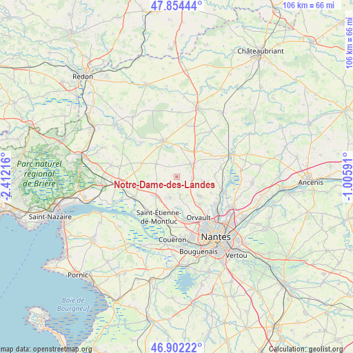
Notre-Dame-des-Landes GPS coordinates[2]
47° 22' 49.728" North, 1° 42' 32.544" West
| Map corner | latitude | longitude |
|---|---|---|
| Upper-left | 47.85444°, | -2.41216° |
| Center: | 47.38048°, | -1.70904° |
| Lower-right: | 46.90222°, | -1.00591° |
| Map W x H: | 105.9×105.9 km | = 65.8×65.8mi |
| max Lat: | 51.07786° ⇑50.4% North |
| Notre-Dame-des-Landes: | 47.38048° |
| min Lat: | ⇓49.6% South 41.3874° |
| min Long | Notre-Dame-des- | max Long |
| -5.08615° | -1.70904° | 9.52242° |
| W 6.5%⇐ | ⇒93.5% E |
Elevation
Elevation of Notre-Dame-des-Landes is 58 m = 190 ft, and this is 135.7 m = 445 ft below average elevation for this country.
| Max E: |
2333 m = 7654 ft | 78.6% |
| Avg. | 193.7 m = 635 ft | |
| Notre-Dame-des-Landes | 58 m = 190 ft | |
Min E: |
-1 m = -3 ft | 21.4% |
See also: France elevation on elevation.city.
Geographical zone
Notre-Dame-des-Landes is located in North temperate zone (between Tropic of Cancer and the Arctic Circle). Distance of this North polar circle is 2133 km =1325.4 mi to North.| Distance of | km | miles | from Notre-Dame-des-Landes |
|---|---|---|---|
| North Pole | 4738.8 | 2944.6 | to North |
| Arctic Circle | 2133 | 1325.4 | to North |
| Tropic Cancer | 2662.3 | 1654.3 | to South |
| Equator | 5268.2 | 3273.5 | to South |


Nearby cities:
15 places around Notre-Dame-des-Landes: (largest is in red/bold)
• Blain
11.4 km =7.1 mi,  339°
339°
• Bouvron
11.1 km =6.9 mi,  291°
291°
• Casson
11.5 km =7.1 mi,  86°
86°
• Fay-de-Bretagne
7.3 km =4.5 mi,  301°
301°
• Héric
5.6 km =3.5 mi,  48°
48°
• La Chapelle-sur-Erdre
15.1 km =9.4 mi,  128°
128°
• La Chevallerais
10.2 km =6.3 mi,  16°
16°
• Le Temple-de-Bretagne
8.4 km =5.2 mi,  225°
225°
• Malville
11.8 km =7.3 mi,  258°
258°
• Orvault
13.8 km =8.6 mi,  151°
151°
• Saint-Étienne-de-Montluc
12.7 km =7.9 mi,  205°
205°
• Sautron
13.4 km =8.3 mi,  167°
167°
• Sucé-sur-Erdre
14.2 km =8.8 mi,  111°
111°
• Treillières
8.8 km =5.5 mi, 129°
• Vigneux-de-Bretagne
6.5 km =4 mi,  198°
198°
Sources, notices
• [Note1] Compared only with cities in France existing in our database
• [Src1] Map data: © OpenStreetMap contributors (CC-BY-SA)
• [Src2] Other city data from geonames.org with taken over terms of usage.
• [Src3] Geographical zone / Annual Mean Temperature by Robert A. Rohde @ Wikipedia
