Rueil-Malmaison geodata
Rueil-Malmaison (Île-de-France) is a populated place; located in France in Europe/Paris (GMT+2) time zone. With population of 76,616 people, there are 60 cities with bigger population in this country. Compared to other cities in France, 77.1% of cities are located further ↓South; 54.6% of cities are located further →East and 76.2% of cities have higher elevation than Rueil-Malmaison. Note1
Administrative division(s):
- Level 1: Île-de-France
- Level 2: Hauts-de-Seine
- Level 3: Arrondissement de Nanterre
- Level 4: Rueil-Malmaison


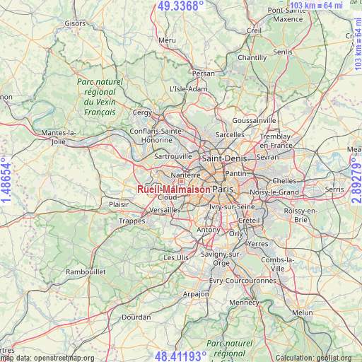
Rueil-Malmaison GPS coordinates[2]
48° 52' 35.4" North, 2° 11' 22.812" East
| Map corner | latitude | longitude |
|---|---|---|
| Upper-left | 49.3368°, | 1.48654° |
| Center: | 48.8765°, | 2.18967° |
| Lower-right: | 48.41193°, | 2.89279° |
| Map W x H: | 102.8×102.8 km | = 63.9×63.9mi |
| max Lat: | 51.07786° ⇑22.9% North |
| Rueil-Malmaison: | 48.8765° |
| min Lat: | ⇓77.1% South 41.3874° |
| min Long | Rueil-Malmaison | max Long |
| -5.08615° | 2.18967° | 9.52242° |
| W 45.4%⇐ | ⇒54.6% E |
Elevation
Elevation of Rueil-Malmaison is 64 m = 210 ft, and this is 129.7 m = 426 ft below average elevation for this country.
| Max E: |
2333 m = 7654 ft | 76.2% |
| Avg. | 193.7 m = 635 ft | |
| Rueil-Malmaison | 64 m = 210 ft | |
Min E: |
-1 m = -3 ft | 23.8% |
See also: Rueil-Malmaison elevation on elevation.city.
Geographical zone
Rueil-Malmaison is located in North temperate zone (between Tropic of Cancer and the Arctic Circle). Distance of this North polar circle is 1966.6 km =1222 mi to North.| Distance of | km | miles | from Rueil-Malmaison |
|---|---|---|---|
| North Pole | 4572.5 | 2841.2 | to North |
| Arctic Circle | 1966.6 | 1222 | to North |
| Tropic Cancer | 2828.6 | 1757.6 | to South |
| Equator | 5434.6 | 3376.9 | to South |


Nearby cities:
15 places around Rueil-Malmaison: (largest is in red/bold)
• Bougival
3.9 km =2.4 mi,  245°
245°
• Carrières-sur-Seine
3.5 km =2.2 mi,  347°
347°
• Chatou
2.7 km =1.7 mi,  303°
303°
• Croissy-sur-Seine
3.8 km =2.4 mi,  274°
274°
• Garches
3.8 km =2.4 mi,  188°
188°
• Houilles
5 km =3.1 mi,  2°
2°
• La Celle-Saint-Cloud
4.4 km =2.7 mi,  228°
228°
• La Defense
4 km =2.5 mi,  64°
64°
• La Garenne-Colombes
5.2 km =3.2 mi,  53°
53°
• Le Vésinet
4.5 km =2.8 mi,  293°
293°
• Nanterre
2.1 km =1.3 mi,  35°
35°
• Puteaux
3.7 km =2.3 mi,  77°
77°
• Saint-Cloud
3.5 km =2.2 mi,  164°
164°
• Suresnes
3 km =1.9 mi,  101°
101°
• Vaucresson
4.7 km =2.9 mi,  211°
211°
Sources, notices
• [Note1] Compared only with cities in France existing in our database
• [Src1] Map data: © OpenStreetMap contributors (CC-BY-SA)
• [Src2] Other city data from geonames.org with taken over terms of usage.
• [Src3] Geographical zone / Annual Mean Temperature by Robert A. Rohde @ Wikipedia
