Neulise geodata
Neulise (Auvergne-Rhône-Alpes) is a populated place; located in France in Europe/Paris (GMT+2) time zone. With population of 1,177 people, there are 7663 cities with bigger population in this country. Compared to other cities in France, 67.6% of cities are located further ↑North; 69.5% of cities are located further ←West and 94.1% of cities have lower elevation than Neulise. Note1
Administrative division(s):
- Level 1: Auvergne-Rhône-Alpes
- Level 2: Département de la Loire
- Level 3: Arrondissement de Roanne
- Level 4: Neulise


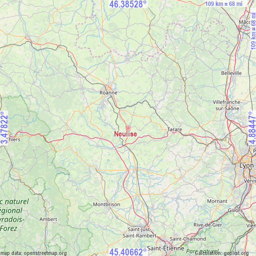
Neulise GPS coordinates[2]
45° 53' 53.196" North, 4° 10' 52.824" East
| Map corner | latitude | longitude |
|---|---|---|
| Upper-left | 46.38528°, | 3.47822° |
| Center: | 45.89811°, | 4.18134° |
| Lower-right: | 45.40662°, | 4.88447° |
| Map W x H: | 108.8×108.8 km | = 67.6×67.6mi |
| max Lat: | 51.07786° ⇑67.6% North |
| Neulise: | 45.89811° |
| min Lat: | ⇓32.4% South 41.3874° |
| min Long | Neulise | max Long |
| -5.08615° | 4.18134° | 9.52242° |
| W 69.5%⇐ | ⇒30.5% E |
Elevation
Elevation of Neulise is 545 m = 1788 ft, and this is 351.3 m = 1153 ft above average elevation for this country.
| Max E: |
2333 m = 7654 ft | 5.9% |
| Neulise | 545 m 1788 ft | |
| Avg. | 193.7 m = 635 ft | |
Min E: |
-1 m = -3 ft | 94.1% |
See also: France elevation on elevation.city.
Geographical zone
Neulise is located in North temperate zone (between Tropic of Cancer and the Arctic Circle). Distance of this North polar circle is 2297.8 km =1427.8 mi to North.| Distance of | km | miles | from Neulise |
|---|---|---|---|
| North Pole | 4903.7 | 3047 | to North |
| Arctic Circle | 2297.8 | 1427.8 | to North |
| Tropic Cancer | 2497.5 | 1551.9 | to South |
| Equator | 5103.4 | 3171.1 | to South |


Nearby cities:
15 places around Neulise: (largest is in red/bold)
• Balbigny
8.8 km =5.5 mi,  175°
175°
• Bussières
9.8 km =6.1 mi,  134°
134°
• Cordelle
10.6 km =6.6 mi,  298°
298°
• Fourneaux
8.3 km =5.2 mi,  56°
56°
• Lay
6.6 km =4.1 mi,  22°
22°
• Nervieux
10.8 km =6.7 mi,  192°
192°
• Néronde
8.1 km =5 mi,  148°
148°
• Pouilly-lès-Feurs
11.9 km =7.4 mi,  160°
160°
• Pradines
11 km =6.8 mi,  357°
357°
• Régny
10.7 km =6.6 mi,  14°
14°
• Saint-Cyr-de-Favières
10.4 km =6.5 mi,  317°
317°
• Saint-Jodard
4.5 km =2.8 mi,  242°
242°
• Saint-Just-la-Pendue
4.7 km =2.9 mi,  95°
95°
• Saint-Marcel-de-Félines
3.4 km =2.1 mi,  167°
167°
• Saint-Symphorien-de-Lay
6 km =3.7 mi, 24°
Sources, notices
• [Note1] Compared only with cities in France existing in our database
• [Src1] Map data: © OpenStreetMap contributors (CC-BY-SA)
• [Src2] Other city data from geonames.org with taken over terms of usage.
• [Src3] Geographical zone / Annual Mean Temperature by Robert A. Rohde @ Wikipedia
