Neauphle-le-Château geodata
Neauphle-le-Château (Île-de-France) is a populated place; located in France in Europe/Paris (GMT+2) time zone. With population of 2,933 people, there are 3322 cities with bigger population in this country. Compared to other cities in France, 75.8% of cities are located further ↓South; 58.2% of cities are located further →East and 60% of cities have lower elevation than Neauphle-le-Château. Note1
Administrative division(s):
- Level 1: Île-de-France
- Level 2: Yvelines
- Level 3: Arrondissement de Rambouillet
- Level 4: Neauphle-le-Château


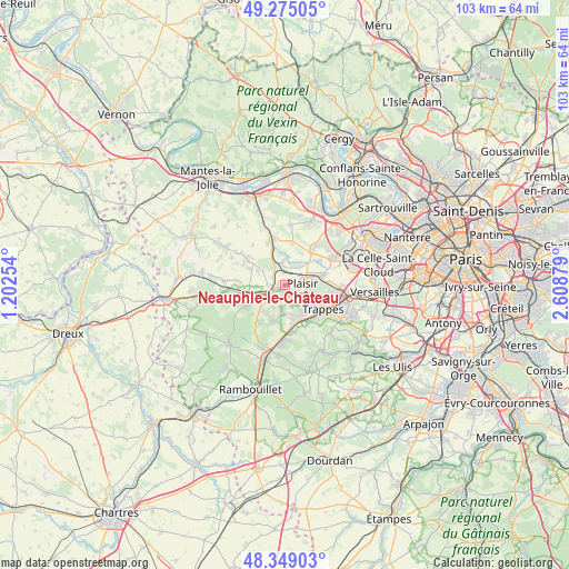
Neauphle-le-Château GPS coordinates[2]
48° 48' 51.048" North, 1° 54' 20.412" East
| Map corner | latitude | longitude |
|---|---|---|
| Upper-left | 49.27505°, | 1.20254° |
| Center: | 48.81418°, | 1.90567° |
| Lower-right: | 48.34903°, | 2.60879° |
| Map W x H: | 103×103 km | = 64×64mi |
| max Lat: | 51.07786° ⇑24.2% North |
| Neauphle-le-Château: | 48.81418° |
| min Lat: | ⇓75.8% South 41.3874° |
| min Long | Neauphle-le-Ch� | max Long |
| -5.08615° | 1.90567° | 9.52242° |
| W 41.8%⇐ | ⇒58.2% E |
Elevation
Elevation of Neauphle-le-Château is 170 m = 558 ft, and this is 23.7 m = 78 ft below average elevation for this country.
| Max E: |
2333 m = 7654 ft | 40% |
| Avg. | 193.7 m = 635 ft | |
| Neauphle-le-Château | 170 m = 558 ft | |
Min E: |
-1 m = -3 ft | 60% |
See also: France elevation on elevation.city.
Geographical zone
Neauphle-le-Château is located in North temperate zone (between Tropic of Cancer and the Arctic Circle). Distance of this North polar circle is 1973.5 km =1226.3 mi to North.| Distance of | km | miles | from Neauphle-le-Château |
|---|---|---|---|
| North Pole | 4579.4 | 2845.5 | to North |
| Arctic Circle | 1973.5 | 1226.3 | to North |
| Tropic Cancer | 2821.7 | 1753.3 | to South |
| Equator | 5427.6 | 3372.6 | to South |


Nearby cities:
15 places around Neauphle-le-Château: (largest is in red/bold)
• Auteuil
7.1 km =4.4 mi,  294°
294°
• Bazoches-sur-Guyonne
5.4 km =3.4 mi,  222°
222°
• Beynes
5.3 km =3.3 mi,  332°
332°
• Jouars-Pontchartrain
2.9 km =1.8 mi,  189°
189°
• Le Tremblay-sur-Mauldre
4.5 km =2.8 mi,  207°
207°
• Les Clayes-sous-Bois
6 km =3.7 mi,  81°
81°
• Maurepas
5.7 km =3.5 mi,  162°
162°
• Neauphle-le-Vieux
3.2 km =2 mi,  272°
272°
• Plaisir
3.7 km =2.3 mi,  74°
74°
• Saint-Germain-de-la-Grange
2.3 km =1.4 mi,  347°
347°
• Saulx-Marchais
5.6 km =3.5 mi,  298°
298°
• Thiverval-Grignon
4 km =2.5 mi,  12°
12°
• Villepreux
6.9 km =4.3 mi, 77°
• Villiers-Saint-Fréderic
1.7 km =1.1 mi,  279°
279°
• Élancourt
4.9 km =3 mi,  132°
132°
Sources, notices
• [Note1] Compared only with cities in France existing in our database
• [Src1] Map data: © OpenStreetMap contributors (CC-BY-SA)
• [Src2] Other city data from geonames.org with taken over terms of usage.
• [Src3] Geographical zone / Annual Mean Temperature by Robert A. Rohde @ Wikipedia
