Noailhac geodata
Noailhac (Occitanie) is a populated place; located in France in Europe/Paris (GMT+2) time zone. With population of 755 people, there are 11114 cities with bigger population in this country. Compared to other cities in France, 92.1% of cities are located further ↑North; 51.8% of cities are located further →East and 73.3% of cities have lower elevation than Noailhac. Note1
Administrative division(s):
- Level 1: Occitanie
- Level 2: Tarn
- Level 3: Arrondissement de Castres
- Level 4: Noailhac


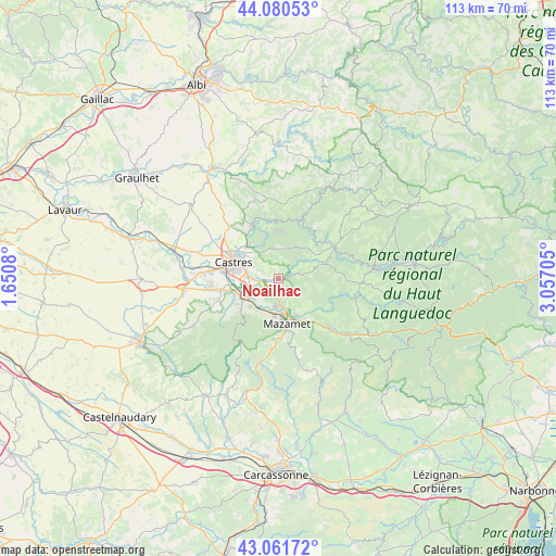
Noailhac GPS coordinates[2]
43° 34' 23.808" North, 2° 21' 14.148" East
| Map corner | latitude | longitude |
|---|---|---|
| Upper-left | 44.08053°, | 1.6508° |
| Center: | 43.57328°, | 2.35393° |
| Lower-right: | 43.06172°, | 3.05705° |
| Map W x H: | 113.3×113.3 km | = 70.4×70.4mi |
| max Lat: | 51.07786° ⇑92.1% North |
| Noailhac: | 43.57328° |
| min Lat: | ⇓7.9% South 41.3874° |
| min Long | Noailhac | max Long |
| -5.08615° | 2.35393° | 9.52242° |
| W 48.2%⇐ | ⇒51.8% E |
Elevation
Elevation of Noailhac is 238 m = 781 ft, and this is 44.3 m = 145 ft above average elevation for this country.
| Max E: |
2333 m = 7654 ft | 26.7% |
| Noailhac | 238 m 781 ft | |
| Avg. | 193.7 m = 635 ft | |
Min E: |
-1 m = -3 ft | 73.3% |
See also: France elevation on elevation.city.
Geographical zone
Noailhac is located in North temperate zone (between Tropic of Cancer and the Arctic Circle). Distance of this Northern Tropic circle is 2239 km =1391.2 mi to South.| Distance of | km | miles | from Noailhac |
|---|---|---|---|
| North Pole | 5162.2 | 3207.6 | to North |
| Arctic Circle | 2556.3 | 1588.4 | to North |
| Tropic Cancer | 2239 | 1391.2 | to South |
| Equator | 4844.9 | 3010.5 | to South |


Nearby cities:
15 places around Noailhac: (largest is in red/bold)
• Aiguefonde
9.3 km =5.8 mi,  198°
198°
• Aussillon
7.9 km =4.9 mi,  171°
171°
• Bout-du-Pont-de-Larn
9.8 km =6.1 mi,  149°
149°
• Burlats
7.6 km =4.7 mi,  338°
338°
• Castres
9.9 km =6.2 mi,  291°
291°
• Labruguière
8.2 km =5.1 mi,  241°
241°
• Lacrouzette
9.7 km =6 mi,  357°
357°
• Lagarrigue
6.1 km =3.8 mi,  274°
274°
• Le Bez
10.5 km =6.5 mi,  69°
69°
• Mazamet
9.4 km =5.8 mi, 170°
• Navès
10.4 km =6.5 mi,  264°
264°
• Payrin-Augmontel
3.2 km =2 mi,  179°
179°
• Pont-de-Larn
8.8 km =5.5 mi, 150°
• Saint-Salvy-de-la-Balme
5.6 km =3.5 mi,  40°
40°
• Valdurenque
3.8 km =2.4 mi, 263°
Sources, notices
• [Note1] Compared only with cities in France existing in our database
• [Src1] Map data: © OpenStreetMap contributors (CC-BY-SA)
• [Src2] Other city data from geonames.org with taken over terms of usage.
• [Src3] Geographical zone / Annual Mean Temperature by Robert A. Rohde @ Wikipedia
