Narbonne geodata
Narbonne (Occitanie) is a seat of a third-order administrative division; located in France in Europe/Paris (GMT+2) time zone. With population of 50,776 people, there are 122 cities with bigger population in this country. Compared to other cities in France, 97.3% of cities are located further ↑North; 57.9% of cities are located further ←West and 97% of cities have higher elevation than Narbonne. Note1
Administrative division(s):
- Level 1: Occitanie
- Level 2: Département de l'Aude
- Level 3: Arrondissement de Narbonne
- Level 4: Narbonne


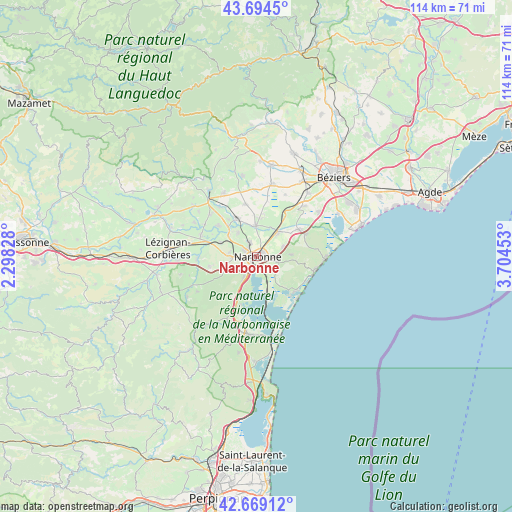
Narbonne GPS coordinates[2]
43° 11' 2.256" North, 3° 0' 5.076" East
| Map corner | latitude | longitude |
|---|---|---|
| Upper-left | 43.6945°, | 2.29828° |
| Center: | 43.18396°, | 3.00141° |
| Lower-right: | 42.66912°, | 3.70453° |
| Map W x H: | 114×114 km | = 70.8×70.8mi |
| max Lat: | 51.07786° ⇑97.3% North |
| Narbonne: | 43.18396° |
| min Lat: | ⇓2.7% South 41.3874° |
| min Long | Narbonne | max Long |
| -5.08615° | 3.00141° | 9.52242° |
| W 57.9%⇐ | ⇒42.1% E |
Elevation
Elevation of Narbonne is 11 m = 36 ft, and this is 182.7 m = 599 ft below average elevation for this country.
| Max E: |
2333 m = 7654 ft | 97% |
| Avg. | 193.7 m = 635 ft | |
| Narbonne | 11 m = 36 ft | |
Min E: |
-1 m = -3 ft | 3% |
See also: Narbonne elevation on elevation.city.
Geographical zone
Narbonne is located in North temperate zone (between Tropic of Cancer and the Arctic Circle). Distance of this Northern Tropic circle is 2195.7 km =1364.3 mi to South.| Distance of | km | miles | from Narbonne |
|---|---|---|---|
| North Pole | 5205.5 | 3234.5 | to North |
| Arctic Circle | 2599.6 | 1615.3 | to North |
| Tropic Cancer | 2195.7 | 1364.3 | to South |
| Equator | 4801.6 | 2983.6 | to South |


Nearby cities:
15 places around Narbonne: (largest is in red/bold)
• Armissan
7.7 km =4.8 mi,  86°
86°
• Bages
6.9 km =4.3 mi,  187°
187°
• Bizanet
10.9 km =6.8 mi,  258°
258°
• Coursan
7.1 km =4.4 mi,  39°
39°
• Fleury
12.2 km =7.6 mi,  64°
64°
• Gruissan
10.9 km =6.8 mi,  140°
140°
• Marcorignan
7.9 km =4.9 mi,  306°
306°
• Montredon-des-Corbières
5.5 km =3.4 mi,  269°
269°
• Moussan
6.7 km =4.2 mi,  321°
321°
• Névian
8.6 km =5.3 mi,  291°
291°
• Ouveillan
11.9 km =7.4 mi,  348°
348°
• Peyriac-de-Mer
11.3 km =7 mi,  198°
198°
• Saint-Marcel-sur-Aude
9.2 km =5.7 mi, 323°
• Saint-Nazaire-d’Aude
11 km =6.8 mi, 308°
• Vinassan
6.4 km =4 mi,  69°
69°
Sources, notices
• [Note1] Compared only with cities in France existing in our database
• [Src1] Map data: © OpenStreetMap contributors (CC-BY-SA)
• [Src2] Other city data from geonames.org with taken over terms of usage.
• [Src3] Geographical zone / Annual Mean Temperature by Robert A. Rohde @ Wikipedia
