Saint-Cloud geodata
Saint-Cloud (Île-de-France) is a populated place; located in France in Europe/Paris (GMT+2) time zone. With population of 28,839 people, there are 293 cities with bigger population in this country. Compared to other cities in France, 76.5% of cities are located further ↓South; 54.4% of cities are located further →East and 51.7% of cities have higher elevation than Saint-Cloud. Note1
Administrative division(s):
- Level 1: Île-de-France
- Level 2: Hauts-de-Seine
- Level 3: Arrondissement de Nanterre
- Level 4: Saint-Cloud


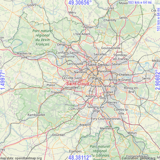
Saint-Cloud GPS coordinates[2]
48° 50' 45.528" North, 2° 12' 10.404" East
| Map corner | latitude | longitude |
|---|---|---|
| Upper-left | 49.30656°, | 1.49977° |
| Center: | 48.84598°, | 2.20289° |
| Lower-right: | 48.38112°, | 2.90602° |
| Map W x H: | 102.9×102.9 km | = 63.9×63.9mi |
| max Lat: | 51.07786° ⇑23.5% North |
| Saint-Cloud: | 48.84598° |
| min Lat: | ⇓76.5% South 41.3874° |
| min Long | Saint-Cloud | max Long |
| -5.08615° | 2.20289° | 9.52242° |
| W 45.6%⇐ | ⇒54.4% E |
Elevation
Elevation of Saint-Cloud is 126 m = 413 ft, and this is 67.7 m = 222 ft below average elevation for this country.
| Max E: |
2333 m = 7654 ft | 51.7% |
| Avg. | 193.7 m = 635 ft | |
| Saint-Cloud | 126 m = 413 ft | |
Min E: |
-1 m = -3 ft | 48.3% |
See also: France elevation on elevation.city.
Geographical zone
Saint-Cloud is located in North temperate zone (between Tropic of Cancer and the Arctic Circle). Distance of this North polar circle is 1970 km =1224.1 mi to North.| Distance of | km | miles | from Saint-Cloud |
|---|---|---|---|
| North Pole | 4575.9 | 2843.3 | to North |
| Arctic Circle | 1970 | 1224.1 | to North |
| Tropic Cancer | 2825.2 | 1755.5 | to South |
| Equator | 5431.2 | 3374.8 | to South |


Nearby cities:
15 places around Saint-Cloud: (largest is in red/bold)
• Bougival
4.8 km =3 mi,  291°
291°
• Boulogne-Billancourt
3 km =1.9 mi,  112°
112°
• Chaville
4.6 km =2.9 mi,  193°
193°
• Garches
1.6 km =1 mi,  254°
254°
• La Celle-Saint-Cloud
4.2 km =2.6 mi,  276°
276°
• La Defense
5.7 km =3.5 mi,  27°
27°
• Marnes-la-Coquette
3.1 km =1.9 mi,  227°
227°
• Meudon
4.3 km =2.7 mi,  146°
146°
• Nanterre
5.1 km =3.2 mi,  3°
3°
• Puteaux
4.9 km =3 mi, 32°
• Rueil-Malmaison
3.5 km =2.2 mi,  344°
344°
• Suresnes
3.4 km =2.1 mi, 34°
• Sèvres
2.8 km =1.7 mi,  157°
157°
• Vaucresson
3.4 km =2.1 mi,  260°
260°
• Ville-d’Avray
2.6 km =1.6 mi,  196°
196°
Sources, notices
• [Note1] Compared only with cities in France existing in our database
• [Src1] Map data: © OpenStreetMap contributors (CC-BY-SA)
• [Src2] Other city data from geonames.org with taken over terms of usage.
• [Src3] Geographical zone / Annual Mean Temperature by Robert A. Rohde @ Wikipedia
